Mont Hochsberg : Différence entre versions
Un article de WikiSimland 3.0.
| Ligne 3: | Ligne 3: | ||
! colspan="2" align="center" valign="middle" height="40" style="font-weight: bold; font-size: 1em; background: #4682b4; color: #ffffff" | <font size="4">'''Mont Hochsberg'''<br/> <font size="1">'' ''</font size> | ! colspan="2" align="center" valign="middle" height="40" style="font-weight: bold; font-size: 1em; background: #4682b4; color: #ffffff" | <font size="4">'''Mont Hochsberg'''<br/> <font size="1">'' ''</font size> | ||
|- | |- | ||
| − | | colspan="2" align="center" |[[Fichier: | + | | colspan="2" align="center" |[[Fichier:Mont Hochsberg.jpg|300px]] |
|- | |- | ||
| <font color=#b0c4de>'''Pays'''</font color> || align="center" | [[Simland]] [[Image:drapeausimland_ico.jpg]] | | <font color=#b0c4de>'''Pays'''</font color> || align="center" | [[Simland]] [[Image:drapeausimland_ico.jpg]] | ||
| Ligne 20: | Ligne 20: | ||
| − | + | ||
| − | + | ||
Version du 30 juin 2016 à 10:46
| Mont Hochsberg | |
|---|---|

| |
| Pays | Simland |
| Région | Whamphalie |
| Etat | Almersprung |
| Massif | Montagnes Rocheuses, Hochsberg. |
| Altitude | 4898 m |
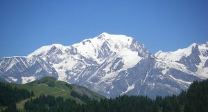
Le Mont Hochsberg est un sommet des Montagnes Rocheuses, situé dans le nord-ouest de la Whamphalie. Il culmine à 4898 mètres d'altitude et fait partie du Parc Naturel du Glacier de l'Hochsberg et du massif de l'Hochsberg, dont il est le point culminant.
| |
Ceci est une page du Portail géographique | |
|---|---|---|
| Découvrez les ressources naturelles de Simland grâce au portail géographique. | ||