Autoroutes nationales : Différence entre versions
Un article de WikiSimland 3.0.
(→Tableau) |
(→Tableau) |
||
| Ligne 36: | Ligne 36: | ||
! scope="row" style="font-weight: bold;" | [[Autoroute A1|A1]] | ! scope="row" style="font-weight: bold;" | [[Autoroute A1|A1]] | ||
| Nord-Sud | | Nord-Sud | ||
| − | | | + | | La méridiene |
| | | | ||
|align="center"| 3000km | |align="center"| 3000km | ||
| Ligne 43: | Ligne 43: | ||
! scope="row" style="font-weight: bold;" | [[Autoroute A2|A2]] | ! scope="row" style="font-weight: bold;" | [[Autoroute A2|A2]] | ||
| Nord-Sud | | Nord-Sud | ||
| − | | | + | | L'autoroute du soleil |
| | | | ||
|align="center"| 2500km | |align="center"| 2500km | ||
| Ligne 50: | Ligne 50: | ||
! scope="row" style="font-weight: bold;" | [[Autoroute A3|A3]] | ! scope="row" style="font-weight: bold;" | [[Autoroute A3|A3]] | ||
| Nord-Sud | | Nord-Sud | ||
| − | | | + | | L'autoroute du nord |
| | | | ||
|align="center"| 3200km | |align="center"| 3200km | ||
| Ligne 57: | Ligne 57: | ||
! scope="row" style="font-weight: bold;" | [[Autoroute A4|A4]] | ! scope="row" style="font-weight: bold;" | [[Autoroute A4|A4]] | ||
| Est-Ouest | | Est-Ouest | ||
| − | | | + | | La transsimlandaise |
| | | | ||
|align="center"| 1500km | |align="center"| 1500km | ||
| Ligne 64: | Ligne 64: | ||
! scope="row" style="font-weight: bold;" | [[Autoroute A5|A5]] | ! scope="row" style="font-weight: bold;" | [[Autoroute A5|A5]] | ||
| Est-Ouest | | Est-Ouest | ||
| − | | | + | | L'eastwestiene |
| | | | ||
|align="center"| 1000km | |align="center"| 1000km | ||
| Ligne 71: | Ligne 71: | ||
! scope="row" style="font-weight: bold;" | [[Autoroute A6|A6]] | ! scope="row" style="font-weight: bold;" | [[Autoroute A6|A6]] | ||
| Est-Ouest | | Est-Ouest | ||
| − | | | + | | L'autoroute blanche |
| | | | ||
|align="center"| 600km | |align="center"| 600km | ||
| Ligne 78: | Ligne 78: | ||
! scope="row" style="font-weight: bold;" | [[Autoroute A7|A7]] | ! scope="row" style="font-weight: bold;" | [[Autoroute A7|A7]] | ||
| Nord-Sud | | Nord-Sud | ||
| − | | | + | | L'avalonienne |
| | | | ||
|align="center"| 800km | |align="center"| 800km | ||
| Ligne 85: | Ligne 85: | ||
! scope="row" style="font-weight: bold;" | [[Autoroute A8|A8]] | ! scope="row" style="font-weight: bold;" | [[Autoroute A8|A8]] | ||
| Nord-Sud | | Nord-Sud | ||
| − | | | + | | La centrale |
| | | | ||
|align="center"| 650km | |align="center"| 650km | ||
| Ligne 92: | Ligne 92: | ||
! scope="row" style="font-weight: bold;" | [[Autoroute A9|A9]] | ! scope="row" style="font-weight: bold;" | [[Autoroute A9|A9]] | ||
| Est-Ouest | | Est-Ouest | ||
| − | | | + | | L'autoroute des plaines |
| | | | ||
|align="center"| 1200km | |align="center"| 1200km | ||
| Ligne 99: | Ligne 99: | ||
! scope="row" style="font-weight: bold;" | [[Autoroute A10|A10]] | ! scope="row" style="font-weight: bold;" | [[Autoroute A10|A10]] | ||
| Nord-Sud | | Nord-Sud | ||
| − | | | + | | La tropical |
| | | | ||
|align="center"| 50km | |align="center"| 50km | ||
| Ligne 106: | Ligne 106: | ||
! scope="row" style="font-weight: bold;" | [[Autoroute A20|A20]] | ! scope="row" style="font-weight: bold;" | [[Autoroute A20|A20]] | ||
| Est-Ouest | | Est-Ouest | ||
| − | | | + | | La russo-méridionale |
| | | | ||
|align="center"| 450km | |align="center"| 450km | ||
| Ligne 113: | Ligne 113: | ||
! scope="row" style="font-weight: bold;" | [[Autoroute A21|A21]] | ! scope="row" style="font-weight: bold;" | [[Autoroute A21|A21]] | ||
| Nord-Sud | | Nord-Sud | ||
| − | | | + | | La psylonienne |
| | | | ||
| align="center"| 75km | | align="center"| 75km | ||
| Ligne 120: | Ligne 120: | ||
! scope="row" style="font-weight: bold;" | [[Autoroute A22|A22]] | ! scope="row" style="font-weight: bold;" | [[Autoroute A22|A22]] | ||
| Est-Ouest | | Est-Ouest | ||
| − | | | + | | L'autoroute des vignes méridionales |
| | | | ||
|align="center"| 350km | |align="center"| 350km | ||
| Ligne 127: | Ligne 127: | ||
! scope="row" style="font-weight: bold;" | [[Autoroute A23|A23]] | ! scope="row" style="font-weight: bold;" | [[Autoroute A23|A23]] | ||
| Est-Ouest | | Est-Ouest | ||
| − | | | + | | L'océane |
| | | | ||
|align="center"| 1500km | |align="center"| 1500km | ||
| Ligne 134: | Ligne 134: | ||
! scope="row" style="font-weight: bold;" | [[Autoroute A24|A24]] | ! scope="row" style="font-weight: bold;" | [[Autoroute A24|A24]] | ||
| Nord-Sud | | Nord-Sud | ||
| − | | | + | | La fédérale |
| | | | ||
|align="center"| 20 km | |align="center"| 20 km | ||
| Ligne 148: | Ligne 148: | ||
! scope="row" style="font-weight: bold;" | [[Autoroute A27|A27]] | ! scope="row" style="font-weight: bold;" | [[Autoroute A27|A27]] | ||
| Nord Sud | | Nord Sud | ||
| − | | | + | | La ckrytaline |
| | | | ||
|align="center"| 30km | |align="center"| 30km | ||
| Ligne 155: | Ligne 155: | ||
! scope="row" style="font-weight: bold;" | [[Autoroute A30|A30]] | ! scope="row" style="font-weight: bold;" | [[Autoroute A30|A30]] | ||
| Nord-Sud | | Nord-Sud | ||
| − | | | + | | L'autoroute verte |
| | | | ||
|align="center"| 100km | |align="center"| 100km | ||
| Ligne 162: | Ligne 162: | ||
! scope="row" style="font-weight: bold;" | [[Autoroute A31|A31]] | ! scope="row" style="font-weight: bold;" | [[Autoroute A31|A31]] | ||
| Nord-Sud | | Nord-Sud | ||
| − | | | + | | La Laurentine |
| | | | ||
|align="center"| 300km | |align="center"| 300km | ||
| Ligne 169: | Ligne 169: | ||
! scope="row" style="font-weight: bold;" | [[Autoroute A32|A32]] | ! scope="row" style="font-weight: bold;" | [[Autoroute A32|A32]] | ||
| Nord-Sud | | Nord-Sud | ||
| − | | | + | | L'autoroute des côtés du Queens |
| | | | ||
|align="center"| 200km | |align="center"| 200km | ||
| Ligne 176: | Ligne 176: | ||
! scope="row" style="font-weight: bold;" | [[Autoroute A33|A33]] | ! scope="row" style="font-weight: bold;" | [[Autoroute A33|A33]] | ||
| Nord-Sud | | Nord-Sud | ||
| − | | | + | | La providentiel |
| | | | ||
|align="center"| 100km | |align="center"| 100km | ||
| Ligne 183: | Ligne 183: | ||
! scope="row" style="font-weight: bold;" | [[Autoroute A34|A34]] | ! scope="row" style="font-weight: bold;" | [[Autoroute A34|A34]] | ||
| Nord-Sud | | Nord-Sud | ||
| − | | | + | | La métropolitaine |
| | | | ||
|align="center"|350km | |align="center"|350km | ||
| Ligne 190: | Ligne 190: | ||
! scope="row" style="font-weight: bold;" | [[Autoroute A35|A35]] | ! scope="row" style="font-weight: bold;" | [[Autoroute A35|A35]] | ||
| Est-Ouest | | Est-Ouest | ||
| − | | | + | | La wyhalaskienne |
| | | | ||
|align="center"| 210km | |align="center"| 210km | ||
| Ligne 197: | Ligne 197: | ||
! scope="row" style="font-weight: bold;" | [[Autoroute A36|A36]] | ! scope="row" style="font-weight: bold;" | [[Autoroute A36|A36]] | ||
| Nord-Sud | | Nord-Sud | ||
| − | | | + | | L'autoroute du nord |
| | | | ||
|align="center"| 150km | |align="center"| 150km | ||
| Ligne 204: | Ligne 204: | ||
! scope="row" style="font-weight: bold;" | [[Autoroute A63|A63]] | ! scope="row" style="font-weight: bold;" | [[Autoroute A63|A63]] | ||
| Nord- Sud | | Nord- Sud | ||
| − | | | + | | L'azuréenne |
| | | | ||
|align="center"| 20 km | |align="center"| 20 km | ||
| Ligne 211: | Ligne 211: | ||
! scope="row" style="font-weight: bold;" | [[Autoroute A101|A101]] | ! scope="row" style="font-weight: bold;" | [[Autoroute A101|A101]] | ||
| Nord-Sud | | Nord-Sud | ||
| − | | | + | | La lakoise |
| | | | ||
|align="center"| 60km | |align="center"| 60km | ||
| Ligne 218: | Ligne 218: | ||
! scope="row" style="font-weight: bold;" | [[Autoroute A331|A331]] | ! scope="row" style="font-weight: bold;" | [[Autoroute A331|A331]] | ||
| Nord-Sud | | Nord-Sud | ||
| − | | | + | | La providentiel |
| | | | ||
|align="center"| 5 km | |align="center"| 5 km | ||
Version du 8 mai 2012 à 13:31
![]() Vous lisez un article de moyenne qualité ayant été classé bronze par les Wiki-administrateurs
Vous lisez un article de moyenne qualité ayant été classé bronze par les Wiki-administrateurs
| AUTOROUTES NATIONALES | |
| | |
| Réseau | |
|---|---|
| Longueur totale | 18 300km |
| Nombre | 27 |

| |
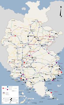
| Carte de Simland | |
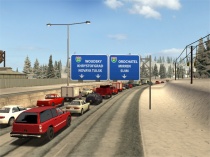
Les autoroutes nationales sont des axes destinés à la circulation automobile de très grande capacité entre les villes de Simland. La circulation s'y fait sur des chaussées en sens unique, à plusieurs voies (au minimum 2x2 voies, voir moins si il y a lieu de traverser des tunnels ou franchir des ponts), afin d'y permettre une circulation fluide et à vive allure. Outre les déplacements automobiles, un grand nombre de camions utilisent le système autoroutier simlandais.
Tableau
| Logo | Nom | Itinéraire | Surnom | Extrémités | Longueur |
|---|---|---|---|---|---|
| |
A1 | Nord-Sud | La méridiene | 3000km | |
| |
A2 | Nord-Sud | L'autoroute du soleil | 2500km | |
| |
A3 | Nord-Sud | L'autoroute du nord | 3200km | |
| |
A4 | Est-Ouest | La transsimlandaise | 1500km | |
| |
A5 | Est-Ouest | L'eastwestiene | 1000km | |
| |
A6 | Est-Ouest | L'autoroute blanche | 600km | |
| |
A7 | Nord-Sud | L'avalonienne | 800km | |
| |
A8 | Nord-Sud | La centrale | 650km | |
| |
A9 | Est-Ouest | L'autoroute des plaines | 1200km | |
| |
A10 | Nord-Sud | La tropical | 50km | |
| |
A20 | Est-Ouest | La russo-méridionale | 450km | |
| |
A21 | Nord-Sud | La psylonienne | 75km | |
| |
A22 | Est-Ouest | L'autoroute des vignes méridionales | 350km | |
| |
A23 | Est-Ouest | L'océane | 1500km | |
| |
A24 | Nord-Sud | La fédérale | 20 km | |
| |
A26 | Est-Ouest | 200km | ||
| |
A27 | Nord Sud | La ckrytaline | 30km | |
| |
A30 | Nord-Sud | L'autoroute verte | 100km | |
| |
A31 | Nord-Sud | La Laurentine | 300km | |
| |
A32 | Nord-Sud | L'autoroute des côtés du Queens | 200km | |
| |
A33 | Nord-Sud | La providentiel | 100km | |
| |
A34 | Nord-Sud | La métropolitaine | 350km | |
| |
A35 | Est-Ouest | La wyhalaskienne | 210km | |
| |
A36 | Nord-Sud | L'autoroute du nord | 150km | |
| |
A63 | Nord- Sud | L'azuréenne | 20 km | |
| |
A101 | Nord-Sud | La lakoise | 60km | |
| |
A331 | Nord-Sud | La providentiel | 5 km |
