District de Goliaski : Différence entre versions
Un article de WikiSimland 3.0.
| (8 révisions intermédiaires par le même utilisateur non affichées) | |||
| Ligne 1: | Ligne 1: | ||
| − | {{ | + | {| class="toccolours" style="float:right;margin: 0em 0em 0em 1em;" |
| + | |- | ||
| + | ! colspan="2" align="center" valign="middle" height="40" style="font-weight: bold; font-size: 1em; background: #004080; color: #ffffff;" | <font size="4">District de Goliaski</font size> | ||
| + | |- | ||
| + | |<font color=#004080> '''Drapeau'''</font size>||[[Fichier:Drapeau district de goliaski.png|220px]] | ||
| + | |- | ||
| + | |<font color=#004080>'''Etat'''</font color> || align="center" | [[Lewsland]] | ||
| + | |- | ||
| + | |<font color=#004080>'''Canton'''</font color> || align="center" | [[Canton de Suim]] | ||
| + | |- | ||
| + | |<font color=#004080>'''Chef-lieu'''</font color> || align="center" | [[Goliaski]] | ||
| + | |- | ||
| + | |<font color=#004080>'''Gentilé'''</font color>|| align="center" | Goliaskiens | ||
| + | |- | ||
| + | |<font color=#004080>'''Population'''</font color> || align="center" | 25 000 hab. | ||
| + | |- | ||
| + | |<font color=#004080>'''Villes importantes'''</font color> || align="center" | '''[[Goliaski]]''' , '''[[Sotcha]]''' , '''[[Nax]]''' , '''[[Untolt]]''' | ||
| + | |- | ||
| + | ! colspan="2" align="center" valign="middle" height="20" style="font-weight: bold; font-size: 1em; background: #004080; color: #ffffff" | <font size="2">'''Situation Géographique'''</font size> | ||
| + | |- | ||
| + | |<font color=#004080> '''Localisation'''</font size>||[[Fichier:District goliaski carte gener.png|250px]] | ||
| + | |- | ||
| + | |<font color=#004080> '''Carte detaillé'''</font size>||[[Fichier:Carte detaille district de goliaski.png|250px]] | ||
| + | |} | ||
| + | |||
| + | A venir | ||
| + | |||
| + | {| class="toccolours" style="margin: 0 2em 0 2em;" | ||
| + | ! style="background:#1F497D; color: #ffffff" align="center" width="100%" | <big>Villes et Villages du District de Goliaski</big> | ||
| + | | [[Image:Sceau goliaski.png|50px]] | ||
| + | |- | ||
| + | |align="center" | [[Goliaski]] ••• [[Nax]] ••• [[Sotcha]] ••• [[Untolt]] ••• [[Hendern]] | ||
| + | |} | ||
| + | |||
| + | |||
| + | [[Catégorie:District de Goliaski]] | ||
Version actuelle en date du 6 novembre 2014 à 12:57
| District de Goliaski | |
|---|---|
| Drapeau | 
|
| Etat | Lewsland |
| Canton | Canton de Suim |
| Chef-lieu | Goliaski |
| Gentilé | Goliaskiens |
| Population | 25 000 hab. |
| Villes importantes | Goliaski , Sotcha , Nax , Untolt |
| Situation Géographique | |
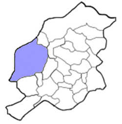
| Localisation | 
|
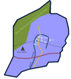
| Carte detaillé | 
|
A venir
| Villes et Villages du District de Goliaski | |
|---|---|
| Goliaski ••• Nax ••• Sotcha ••• Untolt ••• Hendern |