Base aérienne de Cap Ten : Différence entre versions
Un article de WikiSimland 3.0.
| (6 révisions intermédiaires par 4 utilisateurs non affichées) | |||
| Ligne 1: | Ligne 1: | ||
| − | |||
| − | |||
| − | |||
| − | |||
| − | |||
| − | |||
| − | |||
| − | |||
| − | |||
| − | |||
| − | |||
| − | |||
| − | |||
| − | |||
| − | |||
| − | |||
| − | |||
| − | |||
| − | |||
| − | |||
| − | |||
| − | |||
| − | |||
| − | |||
| − | |||
| − | |||
| − | |||
| − | |||
| − | |||
| − | |||
| − | |||
| − | |||
| − | |||
| − | |||
| − | |||
| − | |||
| − | |||
| − | |||
| − | |||
| − | |||
| − | |||
| − | |||
| − | |||
| − | |||
| − | |||
| − | |||
| − | |||
| − | |||
| − | |||
| − | |||
| − | |||
| − | |||
| − | |||
| − | |||
| − | |||
| − | |||
| − | |||
| − | |||
| − | |||
| − | |||
| − | |||
| − | |||
| − | |||
| − | |||
| − | |||
| − | |||
| − | |||
| − | |||
| − | |||
| − | |||
| − | |||
| − | |||
| − | |||
| − | |||
| − | |||
| − | |||
| − | |||
| − | |||
| − | |||
| − | |||
| − | |||
| − | |||
| − | |||
| − | |||
| − | |||
| − | |||
| − | |||
| − | |||
| − | |||
| − | |||
| − | |||
{| class="toccolours" style="float:right;margin: 0em 0em 0em 1em;" | {| class="toccolours" style="float:right;margin: 0em 0em 0em 1em;" | ||
|+ '''[[Armée Simlandaise]]''' | |+ '''[[Armée Simlandaise]]''' | ||
|- | |- | ||
| − | ! colspan="2" align="center" valign="middle" height="40" style="font-weight: bold; font-size: 1em; background:#000033; color: #ffffff" | <font size="4"> | + | ! colspan="2" align="center" valign="middle" height="40" style="font-weight: bold; font-size: 1em; background:#000033; color: #ffffff" | <font size="4">Base aérienne de Cap Ten</font size> |
|- | |- | ||
|- | |- | ||
| colspan="2" align="center" | {{{Photo de la base}}} | | colspan="2" align="center" | {{{Photo de la base}}} | ||
|- | |- | ||
| − | | colspan="2" align="center" | | + | | colspan="2" align="center" | [[Image:Armée de l'air sceau.png|100px]] |
|- | |- | ||
! colspan="2" align="center" valign="middle" height="20" style="font-weight: bold; font-size: 1em; background:#000033; color: #ffffff" | <font size="2">'''Localisation''' | ! colspan="2" align="center" valign="middle" height="20" style="font-weight: bold; font-size: 1em; background:#000033; color: #ffffff" | <font size="2">'''Localisation''' | ||
| Ligne 106: | Ligne 15: | ||
| '''Pays'''|| align="center" | [[Simland]] [[Image:Drapeau de la Nation de Simland.jpg|22px]] | | '''Pays'''|| align="center" | [[Simland]] [[Image:Drapeau de la Nation de Simland.jpg|22px]] | ||
|- | |- | ||
| − | | '''État''' || align="center" | | + | | '''État''' || align="center" | [[Papaya]] [[Image:Papayadrapeau.jpg|22px]] |
|- | |- | ||
| − | | '''Ville''' || align="center" | | + | | '''Ville''' || align="center" | [[Cap Ten]] [[Fichier:Logo.technopole.CapTEN.technopolis.Mega.png|22px]] |
|- | |- | ||
| − | | '''Fondation''' || align="center" | | + | | '''Fondation''' || align="center" | 1972 |
|- | |- | ||
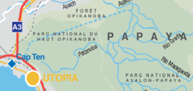
| − | | colspan="2" align="center" |[[Image: | + | | colspan="2" align="center" |[[Image:Localisation.CapTEN.png|280px]]<br> <small>(©[[La Cartographie Nationale|Cartographie Nationale]])</small> |
|- | |- | ||
! colspan="2" align="center" valign="middle" height="20" style="font-weight: bold; font-size: 1em; background:#000033; color: #ffffff" | <font size="2">'''Pistes''' | ! colspan="2" align="center" valign="middle" height="20" style="font-weight: bold; font-size: 1em; background:#000033; color: #ffffff" | <font size="2">'''Pistes''' | ||
| Ligne 126: | Ligne 35: | ||
! colspan="2" align="center" valign="middle" height="20" style="font-weight: bold; font-size: 1em; background:#000033; color: #ffffff" | <font size="2">'''Informations aéronautiques''' | ! colspan="2" align="center" valign="middle" height="20" style="font-weight: bold; font-size: 1em; background:#000033; color: #ffffff" | <font size="2">'''Informations aéronautiques''' | ||
|- | |- | ||
| − | | '''[[Code AITA]]''' || align="center" | | + | | '''[[Code AITA]]''' || align="center" | CDM |
|- | |- | ||
| − | | '''[[Code DACS]]''' || align="center" | | + | | '''[[Code DACS]]''' || align="center" | PP.UA.C0 |
|- | |- | ||
| '''Type d'aéroport''' || align="center" | Militaire | | '''Type d'aéroport''' || align="center" | Militaire | ||
| Ligne 137: | Ligne 46: | ||
| − | + | [[Catégorie: Cap TEN]] | |
Version actuelle en date du 28 octobre 2015 à 09:04
| Base aérienne de Cap Ten | |
|---|---|
| {{{Photo de la base}}} | |

| |
| Localisation | |
| Pays | Simland |
| État | Papaya |
| Ville | Cap Ten |
| Fondation | 1972 |
 (©Cartographie Nationale) | |
| Pistes | |
| Direction | Longueur |
| XXXXX | XXXXX |
| XXXXX | XXXXX |
| Informations aéronautiques | |
| Code AITA | CDM |
| Code DACS | PP.UA.C0 |
| Type d'aéroport | Militaire |
| Gestionnaire | Département de la Défense |

|
BASES AÉRIENNES DE L'ARMÉE DE L'AIR | 
|
|---|---|---|
| Découvrez l'armée Simlandaise grâce au portail de la Défense. | ||