Périphérique de Saint-Louis sur Avalon : Différence entre versions
| Ligne 1: | Ligne 1: | ||
| + | {| class="wikitable" width="250px" style="float:right;margin:0 0 1em 1em;" | ||
| + | |- | ||
| + | | colspan="2" align="center" valign="middle" height="50" style="font-weight: bold; font-size: 1.5em; background: #1e4771; color: #ffffff" | [[Image:Logorocade.jpg|80px|left]]Rocade de<br><br />Saint-Louis sur Avalon | ||
| + | |- | ||
| + | | colspan="2" align="center" valign="middle" height="20" style="font-weight: bold; font-size: 0.90em; background: #4f8ab4; color: #ffffff" | Saint-Louis sur Avalon | ||
| + | |- | ||
| + | | colspan="2" align="center" |[[Image:Carteperiphtresgrand.JPG|250px]] | ||
| + | |- | ||
| + | | colspan="2" align="center" valign="middle" height="20" style="font-weight: bold; font-size: 0.90em; background: #4f8ab4; color: #ffffff" | '''Caractéristiques''' | ||
| + | |- | ||
| + | | Longueur || align="center" | 25km | ||
| + | |- | ||
| + | | Direction || align="center" | Circulaire | ||
| + | |- | ||
| + | | Etat || align="center" | [[Maxisland]] | ||
| + | |- | ||
| + | | Axes majeurs || align="center" | [[A1]]/[[A5]] - [[A510]] | ||
| + | |- | ||
| + | | colspan="2" align="center" valign="middle" height="20" style="font-weight: bold; font-size: 0.90em; background: #4f8ab4; color: #ffffff" | '''Sorties/Bifurcations''' | ||
| + | |- | ||
| + | | align="center" | [[Image:Bifurcation.jpg|16px]] || align="center" | [[A5]]/[[A1]] | ||
| + | |- | ||
| + | | align="center" | [[Image:Sortie.jpg|16px]] || align="center" | <small>[[A5]]</small> Centre Industriel | ||
| + | |- | ||
| + | | align="center" | [[Image:Sortie.jpg|16px]] || align="center" | <small>[[A5]]</small> Les Rosiers | ||
| + | |- | ||
| + | | align="center" | [[Image:Sortie.jpg|16px]] || align="center" | <small>[[A5]]</small> Le Torquet | ||
| + | |- | ||
| + | | align="center" | [[Image:Sortie.jpg|16px]] || align="center" | <small>[[A5]]</small> Centre Ville | ||
| + | |- | ||
| + | | align="center" | [[Image:Sortie.jpg|16px]] || align="center" | <small>[[A5]]</small> Vesuves | ||
| + | |- | ||
| + | | align="center" | [[Image:Pont.jpg|16px]] || align="center" | <small>[[A5]]</small> Pont du Canal | ||
| + | |- | ||
| + | | align="center" | [[Image:Sortie.jpg|16px]] || align="center" | <small>[[A5]]</small> Les Champs | ||
| + | |- | ||
| + | | align="center" | [[Image:Bifurcation.jpg|16px]] || align="center" | [[A5]]/[[A510]] | ||
| + | |- | ||
| + | | align="center" | [[Image:Sortie.jpg|16px]] || align="center" | <small>[[A510]]</small> Corbières | ||
| + | |- | ||
| + | | align="center" | [[Image:Pont.jpg|16px]] || align="center" | <small>[[A510]]</small> Pont d'Haaltert | ||
| + | |- | ||
| + | | align="center" | [[Image:Sortie.jpg|16px]] || align="center" | <small>[[A510]]</small> La chanceraie | ||
| + | |- | ||
| + | | align="center" | [[Image:Pont.jpg|16px]] || align="center" | <small>[[A510]]</small> Pont des Barries | ||
| + | |- | ||
| + | | align="center" | [[Image:Sortie.jpg|16px]] || align="center" | <small>[[A510]]</small> Aizenay | ||
| + | |- | ||
| + | | align="center" | [[Image:Sortie.jpg|16px]] || align="center" | <small>[[A510]]</small> Maillezais | ||
| + | |- | ||
| + | | align="center" | [[Image:Bifurcation.jpg|16px]] || align="center" | A510/A1 | ||
| + | |- | ||
| + | | align="center" | [[Image:Sortie.jpg|16px]] || align="center" | <small>[[A1]]</small> [[Aéroport International Avalon Maxisland]] | ||
| + | |- | ||
| + | | align="center" | [[Image:Sortie.jpg|16px]] || align="center" | <small>[[A1]]</small> La Couronne | ||
| + | |- | ||
| + | | align="center" | [[Image:Sortie.jpg|16px]] || align="center" | <small>[[A1]]</small> Zone Industrielle | ||
| + | |- | ||
| + | | align="center" | [[Image:Sortie.jpg|16px]] || align="center" | <small>[[A1]]</small> Montilieu | ||
| + | |- | ||
| + | | align="center" | [[Image:Pont.jpg|16px]] || align="center" | <small>[[A1]]</small> Pont Sanosuke | ||
| + | |- | ||
| + | | align="center" | [[Image:Sortie.jpg|16px]] || align="center" | [[A1]]/[[A5]] | ||
| + | |- | ||
| + | | colspan="2" align="center" valign="middle" height="20" style="font-weight: bold; font-size: 0.90em; background: #cccccc; color: #ffffff" |<small>[[Saint-Louis sur Avalon|Wiki-Page de la Ville]]</small> | ||
| + | |- | ||
| + | | colspan="2" align="center" |[[Image:Echangeur2.jpg|250px]] | ||
| + | |- | ||
| + | | colspan="2" align="center" |<small>[http://www.simland.biz/forum/ftopic8623.php Voir le topic de la ville]<br/>([[Forums Simland]])</small> | ||
| + | |} | ||
| + | |||
Le '''Périphérique de Saint-Louis sur Avalon''' est la rocade urbaine de la ville de [[Saint-Louis sur Avalon]] dans le [[Maxisland]]. | Le '''Périphérique de Saint-Louis sur Avalon''' est la rocade urbaine de la ville de [[Saint-Louis sur Avalon]] dans le [[Maxisland]]. | ||
Version actuelle en date du 22 juin 2009 à 16:32
| Rocade de Saint-Louis sur Avalon | |
| Saint-Louis sur Avalon | |

| |
| Caractéristiques | |
| Longueur | 25km |
| Direction | Circulaire |
| Etat | Maxisland |
| Axes majeurs | A1/A5 - A510 |
| Sorties/Bifurcations | |
| |
A5/A1 |
| |
A5 Centre Industriel |
| |
A5 Les Rosiers |
| |
A5 Le Torquet |
| |
A5 Centre Ville |
| |
A5 Vesuves |
| |
A5 Pont du Canal |
| |
A5 Les Champs |
| |
A5/A510 |
| |
A510 Corbières |
| |
A510 Pont d'Haaltert |
| |
A510 La chanceraie |
| |
A510 Pont des Barries |
| |
A510 Aizenay |
| |
A510 Maillezais |
| |
A510/A1 |
| |
A1 Aéroport International Avalon Maxisland |
| |
A1 La Couronne |
| |
A1 Zone Industrielle |
| |
A1 Montilieu |
| |
A1 Pont Sanosuke |
| |
A1/A5 |
| Wiki-Page de la Ville | |

| |
| Voir le topic de la ville (Forums Simland) | |
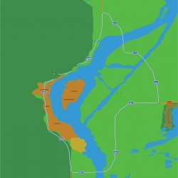
Le Périphérique de Saint-Louis sur Avalon est la rocade urbaine de la ville de Saint-Louis sur Avalon dans le Maxisland.
 A5
A5 
L'A5 est l'axe autoroutier simlandais qui dessert le Sud de Saint-Louis sur Avalon, il est gratuit à partir de la sortie "Les Champs" à l'Ouest de la ville. Il désenclave ensuite les banlieues Sud de Saint-Louis sur Avalon.
A proximité des Rosiers, sera construit le futur échangeur avec l'A1, autre axe majeur de la ville. En Juin 2009, le conseil municipal a décidé de reconstruire l'A1 à l'Est de la ville pour diminuer la pollution en centre historique. Enfin à proximité du village olympique, se trouve un autre échangeur avec l'A500, axe autoroutier gratuit accédant au dit village olympique.
 A1
A1 
L'A1 est l'axe qui dessert l'Aéroport International Avalon Maxisland mais aussi le Nord et l'Est de Simland. L'autoroute est gratuite depuis l'Aéroport jusqu'à l'échangeur A1/A5.
 A510
A510 
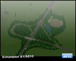
L'A510 est une autoroute gratuite qui sera bientôt construite pour relier l'Aéroport International Avalon Maxisland à l'A5 plus rapidement, elle servira aussi de rocade au Nord Ouest de Simland.
