Heiwashima : Différence entre versions
| Ligne 1: | Ligne 1: | ||
{| class="wikitable" width="250px" style="float:right;margin: 0em 0em 0em 1em;" | {| class="wikitable" width="250px" style="float:right;margin: 0em 0em 0em 1em;" | ||
| − | ! colspan="2" align="center" height="25" style="font-weight: bold; font-size: 1em; background: # | + | ! colspan="2" align="center" height="25" style="font-weight: bold; font-size: 1em; background: #250099" | [[Villes de Simland]] |
| + | |- | ||
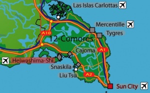
| + | | colspan="2" align="center" |[[Image:Barreheiwashimajpg.jpg|300px]] | ||
|- | |- | ||
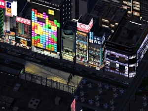
| colspan="2" align="center" | [[Image:Hankagai.jpg|300px]] | | colspan="2" align="center" | [[Image:Hankagai.jpg|300px]] | ||
<font size="1">Hankagai, le "Shibuya" heiwashiman.</font size> | <font size="1">Hankagai, le "Shibuya" heiwashiman.</font size> | ||
| − | |||
| − | |||
| − | |||
|- | |- | ||
| − | ! colspan="2" align="center" valign="middle" height="30" style="font-weight: bold; font-size: 1em; background: # | + | | colspan="2" align="center" | [[Image:Drapeau Heiwashima.jpg|100px]] |
| + | <font size="1">Drapeau de la Municapilé d'Heiwashima-Shi</font size> | ||
| + | |- | ||
| + | ! colspan="2" align="center" valign="middle" height="30" style="font-weight: bold; font-size: 1em; background: #250099; color: #ffffff" | Heiwashima-Shi<br/> <font size="2">市平和島</font size><br/> <font size="1">''L'île de la paix''</font size> | ||
| + | |- | ||
| + | | '''Pays''' || [[Simland]] [[Image:drapeausimland_ico.jpg]] | ||
| + | |- | ||
| + | | '''État''' || [[Comores]] [[Image:Drapeaucomores2.jpg|20px]] | ||
| + | |- | ||
| + | | '''Département''' || Iztachuatl [[Image:Drapeaucomores2.jpg|20px]] | ||
|- | |- | ||
| − | | | + | | '''Maire''' || [[Wizz-Y|William S. Poznanski]] |
|- | |- | ||
| − | + | ! colspan="2" align="center" valign="middle" height="30" style="font-weight: bold; font-size: 1em; background: #250099; color: #ffffff" | <font size="1">Géographie</font size> | |
|- | |- | ||
| − | | | + | | '''Île''' || Île de Los Corozos |
|- | |- | ||
| − | | | + | | '''Superficie''' || 80,4 km² |
|- | |- | ||
| − | | | + | | '''Altitude''' || 0 - 177 m ([[Iztachuatl]]) |
|- | |- | ||
| − | + | ! colspan="2" align="center" valign="middle" height="30" style="font-weight: bold; font-size: 1em; background: #250099; color: #ffffff" | <font size="1">Démographie (20 octobre 2010)</font size> | |
|- | |- | ||
| − | + | | '''Population''' || 600.000 | |
|- | |- | ||
| − | | | + | | '''Densité''' || 7463 habitants/km |
|- | |- | ||
| − | | | + | | '''Disticts''' || 8 |
|- | |- | ||
| − | | | + | | '''Code Postal''' || 12 300 |
|- | |- | ||
| − | + | ! colspan="2" align="center" valign="middle" height="30" style="font-weight: bold; font-size: 1em; background: #250099; color: #ffffff" | <font size="1">Symboles municipaux</font size> | |
|- | |- | ||
| − | | | + | | '''Fleur''' || Fleur du cerisier (''Sakura'') |
|- | |- | ||
| − | | | + | | '''Arbre''' || Cerisier oriental (''Prunus serrulata'') |
|- | |- | ||
| − | | | + | | '''Oiseau''' || Ibis nippon (''Nipponia nippon'') |
| − | + | ||
|- | |- | ||
| colspan="2" align="center" | [http://www.simland.biz/forum/ftopic10552.php Topic de la ville] | | colspan="2" align="center" | [http://www.simland.biz/forum/ftopic10552.php Topic de la ville] | ||
Version du 30 mars 2011 à 09:32
| Villes de Simland | |
|---|---|

Hankagai, le "Shibuya" heiwashiman. | |

Drapeau de la Municapilé d'Heiwashima-Shi | |
| Heiwashima-Shi 市平和島 L'île de la paix | |
| Pays | Simland |
| État | Comores |
| Département | Iztachuatl |
| Maire | William S. Poznanski |
| Géographie | |
| Île | Île de Los Corozos |
| Superficie | 80,4 km² |
| Altitude | 0 - 177 m (Iztachuatl) |
| Démographie (20 octobre 2010) | |
| Population | 600.000 |
| Densité | 7463 habitants/km |
| Disticts | 8 |
| Code Postal | 12 300 |
| Symboles municipaux | |
| Fleur | Fleur du cerisier (Sakura) |
| Arbre | Cerisier oriental (Prunus serrulata) |
| Oiseau | Ibis nippon (Nipponia nippon) |
| Topic de la ville | |

| |
Heiwashima-Shi, (littéralement 市 pour ville (-shi), 平和 pour paix (heiwa) et 島 pour île (shima)) ou anciennement République d'Heiwashima est une ancienne cité-Etat du Pacifique, annexé aux Comores puis à Simland suite à la crise asiatique le 1/01/2001, selon les accords de Koishima-Ku [CM].
Île volcanique influencée depuis sa tendre enfance par la culture niponne, cette municipalité insulaire est une enclave du monde asiatique, dans un monde de culture plus européenne. A ce jour, Heiwashima-Shi une ville métissée et multiculturelle.
Plaque tournante entre le Japon, la Chine, les NPIA (République de Chine, RAS de Hong-Kong, Singapour et la Corée du Sud) et l'ensemble Simlando-américain, elle a su être un centre important de l'économie mondiale, surtout grâce aux transports maritimes et à son passé japonais.
Histoire
La légende et quelques écrits apportent la naissance d'Heiwashima au VIe siècle par l'arrivée de moines boudhistes coréens et chinois, l'île étant encore déserte, cause de l'activité régulière du volcan Enten, signifiant "Soleil brulant". (ce nom sera donné au XIVe Siècle, lors de la découverte de ces premiers écrits, la langue utilisé étant le vieux japonais entre le IVe et le XIIe siècle), volcan aujourd'hui inactif.