Aéroport International de Santa Maria : Différence entre versions
Un article de WikiSimland 3.0.
M |
|||
| Ligne 1: | Ligne 1: | ||
| − | {| class=" | + | {| class="toccolours" style="float:right;margin: 0em 0em 0em 1em;" |
| + | |+ '''[[Aéroports de Simland]]''' | ||
|- | |- | ||
| − | + | ! colspan="2" align="center" valign="middle" height="40" style="font-weight: bold; font-size: 1em; background:#0e89b5; color: #ffffff" | <font size="4">[[Image:Icone-avion.jpg]]SANTA MARIA INTERNATIONAL</font size> | |
|- | |- | ||
| − | | colspan="2" align="center" |[[Image: | + | | colspan="2" align="center" | [[Image:TransportforMercentLogo.png|290px]] |
| − | | | + | |- |
| + | | colspan="2" align="center" | [[Image:AeroportSantaMariaLC.jpg|290px]] | ||
|- | |- | ||
! colspan="2" align="center" valign="middle" height="20" ; font-size: 1em; background: #ffffff; color: #000000"| Code [[AITA]] <br> '''TNM''' | ! colspan="2" align="center" valign="middle" height="20" ; font-size: 1em; background: #ffffff; color: #000000"| Code [[AITA]] <br> '''TNM''' | ||
|- | |- | ||
| − | ! colspan="2" align="center" valign="middle" height="20" style="font-weight: bold; font-size: 1em; background: #0e89b5; color: #ffffff"| Localisation | + | ! colspan="2" align="center" valign="middle" height="20" style="font-weight: bold; font-size: 1em; background:#0e89b5; color: #ffffff" | <font size="2">'''Localisation''' |
|- | |- | ||
| − | | Pays || align="center" | [[Image:Drapeau de la Nation de Simland.jpg| | + | | '''Pays'''|| align="center" | [[Simland]] [[Image:Drapeau de la Nation de Simland.jpg|22px]] |
| − | + | ||
| − | + | ||
|- | |- | ||
| − | | | + | | '''État''' || align="center" | [[Papaya]] [[Image:Papayadrapeau.jpg|22px]] |
|- | |- | ||
| − | | | + | | '''Ville''' || align="center" | [[Santa Maria]] [[Fichier:SealofTheCityOfSantaMaria.png|22px]] |
|- | |- | ||
| − | + | | '''Superficie''' || align="center" | 2 900 ha | |
|- | |- | ||
| − | | | + | | '''Altitude''' || align="center" | 15 m (51 ft) |
|- | |- | ||
| − | | | + | | colspan="2" align="center" |[[Image:Localisationsm.png|280px]]<br> <small>Localisation de l'Aéroport International de Santa Maria<br> (©[[La Cartographie Nationale|Cartographie Nationale]])</small> |
|- | |- | ||
| − | + | ! colspan="2" align="center" valign="middle" height="20" style="font-weight: bold; font-size: 1em; background:#0e89b5; color: #ffffff" | <font size="2">'''Pistes''' | |
|- | |- | ||
| − | + | |- {| class="wikitable" align="center" style="font-size: 85%;" | |
|- | |- | ||
| − | | | + | | bgcolor="#E4E4E4" | '''Direction''' || bgcolor="#E4E4E4" | '''Longueur''' |
|- | |- | ||
| − | | | + | | bgcolor="#efefef" | 28L/10R || 2 950 m (9 678 ft) |
| + | |- | ||
| + | | bgcolor="#efefef" | 28R/10L || 3 000 m (9 852 ft) | ||
| + | |- | ||
| + | ! colspan="2" align="center" valign="middle" height="20" style="font-weight: bold; font-size: 1em; background:#0e89b5; color: #ffffff" | <font size="2">'''Informations aéronautiques''' | ||
| + | |- | ||
| + | | '''[[Code AITA]]''' || align="center" | TNM | ||
| + | |- | ||
| + | | '''Code OACI''' || align="center" | ITNM | ||
| + | |- | ||
| + | | '''[[Code DACS]]''' || align="center" | PP.MT.S1 | ||
| + | |- | ||
| + | | '''Nom cartographique''' || align="center" | Santa Maria-International | ||
| + | |- | ||
| + | | '''Type d'aéroport''' || align="center" | Civil | ||
| + | |- | ||
| + | | '''Gestionnaire''' || align="center" | Transport for Mercent | ||
| + | |- | ||
| + | ! colspan="2" align="center" valign="middle" height="20" style="font-weight: bold; font-size: 1em; background:#0e89b5; color: #ffffff" | <font size="2">'''Statistiques 2014''' | ||
| + | |- | ||
| + | | '''Passagers''' || align="center" | NC | ||
| + | |- | ||
| + | | '''Mouvements aériens''' || align="center" | NC | ||
| + | |- | ||
| + | | '''Cargo (tonnes métriques)''' || align="center" | NC | ||
| + | |- | ||
| + | | '''Impact économique''' || align="center" | NC | ||
|- | |- | ||
| − | |||
|} | |} | ||
| + | L'<b>Aéroport International de Santa Maria</b> (Code [[AITA]] : TNM) est un aéroport simlandais situé dans l'État de [[Papaya]], à l'extrémité sud de la ville de [[Santa Maria]] au [[Mercent]]. L'aéroport de Santa Maria constitue un des principaux nœuds aéroportuaire de [[Simland]]. | ||
| + | L'aéroport de Santa Maria constitue aujourd'hui le Hub principal de la compagnie aérienne simlandaise [[Royal Mercent Airways]]. Il est également largement desservit par les grandes compagnie simlandaises et internationales | ||
| − | + | ''en construction'' | |
| − | + | ||
| − | + | ||
| − | + | ||
| − | + | ||
| − | + | ||
| − | + | ||
| − | + | ||
| − | + | ||
| − | + | ||
| − | + | ||
| − | + | ||
| − | + | ||
| − | + | ||
| − | + | ||
| − | + | ||
| − | + | ||
| − | + | ||
| − | + | ||
| − | + | ||
| − | + | ||
| − | + | ||
| − | + | ||
| − | + | ||
| − | + | ||
| − | + | ||
| − | + | ||
| − | + | ||
| − | + | ||
| − | + | ||
| − | + | ||
| − | + | ||
| − | + | ||
| − | + | ||
| − | + | ||
| − | + | ||
| − | + | ||
| − | + | ||
| − | + | ||
| − | + | ||
| − | + | ||
| − | + | ||
| − | + | ||
| − | + | ||
| − | + | ||
| − | + | ||
| − | + | ||
| − | + | ||
| − | + | ||
| − | + | ||
| − | + | ||
| − | + | ||
| − | + | ||
| − | + | ||
| − | + | ||
| − | + | ||
| − | + | ||
| − | + | ||
| − | + | ||
| − | + | ||
| − | + | ||
| − | + | ||
| − | + | ||
| − | + | ||
| − | + | ||
| − | + | ||
| − | + | ||
| − | + | ||
| − | + | ||
| − | + | ||
| − | + | ||
| − | + | ||
| − | + | ||
| − | + | ||
{{Transports Mercentais (bandeau)}} | {{Transports Mercentais (bandeau)}} | ||
Version du 1 novembre 2014 à 20:41
| | |
|---|---|

| |

| |
| Code AITA TNM | |
| Localisation | |
| Pays | Simland |
| État | Papaya |
| Ville | Santa Maria |
| Superficie | 2 900 ha |
| Altitude | 15 m (51 ft) |
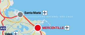
 Localisation de l'Aéroport International de Santa Maria (©Cartographie Nationale) | |
| Pistes | |
| Direction | Longueur |
| 28L/10R | 2 950 m (9 678 ft) |
| 28R/10L | 3 000 m (9 852 ft) |
| Informations aéronautiques | |
| Code AITA | TNM |
| Code OACI | ITNM |
| Code DACS | PP.MT.S1 |
| Nom cartographique | Santa Maria-International |
| Type d'aéroport | Civil |
| Gestionnaire | Transport for Mercent |
| Statistiques 2014 | |
| Passagers | NC |
| Mouvements aériens | NC |
| Cargo (tonnes métriques) | NC |
| Impact économique | NC |
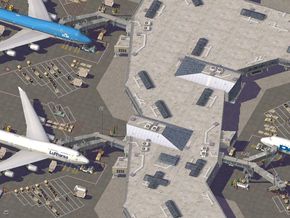
L'Aéroport International de Santa Maria (Code AITA : TNM) est un aéroport simlandais situé dans l'État de Papaya, à l'extrémité sud de la ville de Santa Maria au Mercent. L'aéroport de Santa Maria constitue un des principaux nœuds aéroportuaire de Simland. L'aéroport de Santa Maria constitue aujourd'hui le Hub principal de la compagnie aérienne simlandaise Royal Mercent Airways. Il est également largement desservit par les grandes compagnie simlandaises et internationales
en construction
| <span; style="font-weight: ; font-size: 1.0em; color: #ffffff ">Transports du Mercent</span> | | |
|---|---|---|
| Gare Mercentille - King George VI | ||
| Aéroports Mercentille - William J. Clinton International • Aéroport International de Santa Maria | ||
| Ports Portheaven Harbour • Port International de Santa Maria | ||

|