Aéroport international de Cap TEN : Différence entre versions
Un article de WikiSimland 3.0.
| Ligne 20: | Ligne 20: | ||
| '''Etat''' || align="center" | [[Fichier:Papayadrapeau.jpg|20px]] [[Papaya]] | | '''Etat''' || align="center" | [[Fichier:Papayadrapeau.jpg|20px]] [[Papaya]] | ||
|- | |- | ||
| − | | '''Villes desservies''' || align="left" |[[Fichier: | + | | '''Villes desservies''' || align="left" |[[Fichier:Utopia.logo.jpg|60px]] [[Utopia]] <br> [[Fichier:Logo.technopole.CapTEN.technopolis.Mega.png|60px]] [[Cap Ten | Cap TEN]] <br> [[Fichier:Logovilleeslandias.png|60px]] [[Eslandias]] |
|- | |- | ||
| '''Altitude''' || align="center" | 30 mètres | | '''Altitude''' || align="center" | 30 mètres | ||
Version du 21 février 2015 à 09:38
| | ||

|
||
| Code AITA | CDX | |
| Code OACI | PSCX | |
| Localisation | ||
|---|---|---|

| ||
| Pays | | |
| Etat | | |
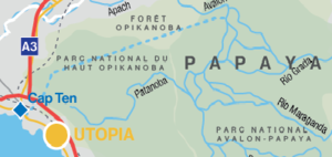
| Villes desservies | ||
| Altitude | 30 mètres | |
| Informations techniques | ||
| Pistes | Nombres: 4 pistes direction : Nord-Sud Nord Ouest - Sud Est longueur : 4500 mètres largeur : 60 mètres surface : tarmac | |
| Parkings | 22 | |
| Informations commerciales | ||
| Type d'aéroport | Civil | |
| Terminaux | 2 | |
| Mouvement commerciaux | 229 654 (2014) | |
| Passagers | 28 274 154 (2014) | |
| Fret en tonne | 94 270 (2014) | |
| Gestionnaire | Mairie d'Utopia | |
| Directeur | Mario dos santos de la plancha | |