Cartographie du Lewsland : Différence entre versions
Un article de WikiSimland 3.0.
| Ligne 23: | Ligne 23: | ||
<gallery> | <gallery> | ||
| − | Fichier:Lw3 by yulanglay-d7eyfl2.png | + | Fichier:Lw3 by yulanglay-d7eyfl2.png | '''Subdivisions Administratives''' |
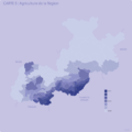
| − | Fichier:Lw4 by yulanglay-d7eyflq.png | + | Fichier:Lw4 by yulanglay-d7eyflq.png | '''Densité de Population''' |
| − | Fichier:Lw2 by yulanglay-d7eygh2.png | + | Fichier:Lw2 by yulanglay-d7eygh2.png | '''Les Villes''' |
| − | Fichier:Cartelw9 by yulanglay-d7io61h.png | + | Fichier:Cartelw9 by yulanglay-d7io61h.png | '''Ville Rp''' |
| − | Fichier:Cartelw8 by yulanglay-d7io613.png | + | Fichier:Cartelw8 by yulanglay-d7io613.png | '''Transports Ferroviers''' |
| − | Fichier:Cartelw7 by yulanglay-d7io60k.png | + | Fichier:Cartelw7 by yulanglay-d7io60k.png | '''Transports Routiers''' |
| − | Fichier:Cartelw5 by yulanglay-d7io5w5.png | + | Fichier:Cartelw5 by yulanglay-d7io5w5.png | '''Agriculture de la Région''' |
| − | Fichier:Cartelw6 by yulanglay-d7io5x5.png | + | Fichier:Cartelw6 by yulanglay-d7io5x5.png | '''Langues''' |
| − | Fichier:Cartelw1 by yulanglay-d6sq2mb.png | + | Fichier:Cartelw1 by yulanglay-d6sq2mb.png | '''Lewsland''' |
</gallery> | </gallery> | ||
Version du 17 octobre 2014 à 17:35
| Cartographie du Lewsland | |
|---|---|
| Informations Générales | |
| Etat | Lewsland, LWD, 01 |
| Type | Cartographie |
| Création | 2014 |
| Structure | |
| Fonctionnaires | 10 |
| Budget | 1 350 000 §imléons |
La Cartographie Lewslandaise est une institution lewslandaise assignée à l'établissement des cartes et des vues aériennes du Lewsland. Elle dépend du Leader du Lewsland et de La Cartographie Nationale, qui en est l'équivalent Fédéral.
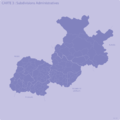
Subdivisions Administratives
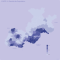
Densité de Population

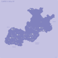
Les Villes
Ville Rp

Transports Ferroviers
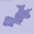
Transports Routiers
Agriculture de la Région
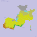
Langues

Lewsland


