Untolt : Différence entre versions
Un article de WikiSimland 3.0.
(→Découvrir) |
|||
| (18 révisions intermédiaires par le même utilisateur non affichées) | |||
| Ligne 1: | Ligne 1: | ||
| + | {{Modèle:Village LWD}} | ||
{| class="wikitable" width="260px" style="float:right;margin:0 0 1em 1em;" | {| class="wikitable" width="260px" style="float:right;margin:0 0 1em 1em;" | ||
| colspan="2" align="center" valign="middle" height="50" style="font-weight: bold; font-size: 1.5em; background: #1F497D; color: #ffffff" | Commune d'Untolt | | colspan="2" align="center" valign="middle" height="50" style="font-weight: bold; font-size: 1.5em; background: #1F497D; color: #ffffff" | Commune d'Untolt | ||
|+ style="font-size: 1.25em;" | {{nobr|'''[[Goliaski]]'''}} | |+ style="font-size: 1.25em;" | {{nobr|'''[[Goliaski]]'''}} | ||
|- | |- | ||
| − | | colspan="2" align="center" |<br>[[Image:???|280px]] [[Fichier: | + | | colspan="2" align="center" |<br>[[Image:???|280px]] [[Fichier:Carte untolt ggg.png|280px]] <br><br> <small><b>''Photo et Plan de la commune''</b></small> |
|- | |- | ||
| colspan="2" align="center" valign="middle" height="10" style="font-weight; font-size: 1em; background: #1F497D; color: #ffffff" | Localisation | | colspan="2" align="center" valign="middle" height="10" style="font-weight; font-size: 1em; background: #1F497D; color: #ffffff" | Localisation | ||
| Ligne 17: | Ligne 18: | ||
|colspan="2" align="center" valign="middle" height="10" style="font-weight; font-size: 1em; background: #1F497D; color: #ffffff" | Activités principales | |colspan="2" align="center" valign="middle" height="10" style="font-weight; font-size: 1em; background: #1F497D; color: #ffffff" | Activités principales | ||
|- | |- | ||
| − | | | + | | Activité || align="center" | ??? |
|- | |- | ||
|colspan="2" align="center" valign="middle" height="10" style="font-weight; font-size: 1em; background: #1F497D; color: #ffffff" | Géographie | |colspan="2" align="center" valign="middle" height="10" style="font-weight; font-size: 1em; background: #1F497D; color: #ffffff" | Géographie | ||
| Ligne 28: | Ligne 29: | ||
|} | |} | ||
| + | {| class="toccolours" style="margin: 0 2em 0 2em;" | ||
| + | ! style="background:#1F497D; color: #ffffff" align="center" width="100%" | <big>Communes et Villages de l'agglomeration de Goliaski</big> | ||
| + | | [[Image:Sceau goliaski.png|50px]] | ||
| + | |- | ||
| + | |align="center" | [[Nax]] ••• [[Sotcha]] ••• [[Untolt]] | ||
| + | |} | ||
==[[Fichier:Sceau goliaski.png|30px]] Historique du village == | ==[[Fichier:Sceau goliaski.png|30px]] Historique du village == | ||
| Ligne 47: | Ligne 54: | ||
*Grotte d'Untolt et sa boutique de pierre précieuses | *Grotte d'Untolt et sa boutique de pierre précieuses | ||
*Temple du Panthéon Nordique | *Temple du Panthéon Nordique | ||
| + | *Bureau du Sherif d'Untolt | ||
| + | *Terminal de [http://wiki.simland.eu/Goliaski#Goliath-bus Goliath Bus] de l'agglomeration de Goliaski | ||
| + | *Entrepot de [http://wiki.simland.eu/Goliaski#Taxi-Goliath Taxi Goliath] | ||
| + | *Ranch des gardes forestiers | ||
| + | *[[Milopolis|Restaurant Fast'N'Eco]] | ||
===Loisirs=== | ===Loisirs=== | ||
| Ligne 52: | Ligne 64: | ||
==[[Fichier:Sceau goliaski.png|30px]] Quelques images == | ==[[Fichier:Sceau goliaski.png|30px]] Quelques images == | ||
| + | <gallery> | ||
| + | Fichier:Fast'N'Eco Goliaski 175.jpg|''Restaurant Fast'N'Eco'' | ||
| + | </gallery> | ||
| − | + | [[Catégorie:District de Goliaski]] | |
| − | + | ||
| − | + | ||
| − | + | ||
| − | + | ||
| − | + | ||
Version actuelle en date du 7 mars 2016 à 11:33
| Villages du Lewsland | |
|---|---|
| Leydammer | Aspères | Hareuilles | Mannyberg | Nevala | Thoiras | Nax | Sotcha | Untolt | Dollin | Gressy | Loewenberg | Neuendorf | Wengen | Yverdin | Welwer | Goliaskistrass |Tchoutchoka sur le Lewsland | Kamtchaka sur le Lewsland |
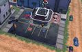
| Commune d'Untolt | |
280px  Photo et Plan de la commune | |
| Localisation | |
| Ville | Goliaski |
| Démographie | |
| Population (2013) | ??? habs |
| Activités principales | |
| Activité | ??? |
| Géographie | |
| Superficie | ??? km² |
| Altitude | +2341 m |
| Communes et Villages de l'agglomeration de Goliaski | |
|---|---|
| Nax ••• Sotcha ••• Untolt |
Sommaire
 Historique du village
Particularités du village
A découvrir
Patrimoine
Découvrir
- Mine d’uranium , de fer , de platine , d'émeraudes , d’étain et de charbon
- Centre de stockages des ressources minières
- Centre d'acheminement des ressources minières
- Entreprise de Gestion des ressources minières "Minos"
- Bijouterie d'émeraude
- Grotte d'Untolt et sa boutique de pierre précieuses
- Temple du Panthéon Nordique
- Bureau du Sherif d'Untolt
- Terminal de Goliath Bus de l'agglomeration de Goliaski
- Entrepot de Taxi Goliath
- Ranch des gardes forestiers
- Restaurant Fast'N'Eco
Loisirs
Quelques images
Restaurant Fast'N'Eco
