Carthographie Thoulakienne : Différence entre versions
(→center|100px45pxCarte Administrative) |
|||
| Ligne 1: | Ligne 1: | ||
| − | [[ | + | <div style="float:right; margin:0 0 1em 2em; text-align:right; font-size:1em; font-family:lucida grande, sans-serif; line-height:normal;"> |
| + | <div style="border: 5px solid #800000; background: #FFFFFF; text-align: left; padding: 0.5em 1em; text-align: center;"> | ||
| + | <big>'''Entreprise Thoulakienne'''</big> <br> | ||
| + | <div align=center> | ||
| + | [[Image:IMS.png|225px]] | ||
| + | </div> | ||
| + | |||
| + | {| style="background:transparent; text-align:left; table-layout:auto; border-collapse:collapse; padding:0; width:300px; font-size:100%;" cellspacing="0" cellpadding="0" | ||
| + | |- | ||
| + | | colspan=2 style="border-top: solid 2px #800000; padding:0.4em 1em 0.4em 0; vertical-align:top; text-align:center;" |'''La Cartographie Thoulakienne''' | ||
| + | |- | ||
| + | ! style="border-top: solid 2px #800000; padding: 0.4em 1em 0.4em 0; vertical-align: top; text-align: left;" | Création | ||
| + | | style="border-top: solid 2px #800000; padding: 0.4em 1em 0.4em 0; vertical-align: top" | Juin 2013 | ||
| + | |- | ||
| + | ! style=" padding: 0.4em 1em 0.4em 0; vertical-align: top; text-align: left;" | Dates clef | ||
| + | | style=" padding: 0.4em 1em 0.4em 0; vertical-align: top" | Juin 2013 (Fondation)<br>Nov. 2016 (Reprise) | ||
| + | |- | ||
| + | ! style=" padding: 0.4em 1em 0.4em 0; vertical-align: top; text-align: left;" | Fondateur | ||
| + | | style=" padding: 0.4em 1em 0.4em 0; vertical-align: top" | [[Metri]] | ||
| + | |- | ||
| + | ! style=" padding: 0.4em 1em 0.4em 0; vertical-align: top; text-align: left;" | PDG Actuel | ||
| + | | style=" padding: 0.4em 1em 0.4em 0; vertical-align: top" | [[Yeskiomach]] | ||
| + | |- | ||
| + | ! style=" padding: 0.4em 1em 0.4em 0; vertical-align: top; text-align: left;" | Slogan | ||
| + | | style=" padding: 0.4em 1em 0.4em 0; vertical-align: top" | '' - '' | ||
| + | |- | ||
| + | ! style=" padding: 0.4em 1em 0.4em 0; vertical-align: top; text-align: left;" | Siège social | ||
| + | | style=" padding: 0.4em 1em 0.4em 0; vertical-align: top" | [[Image:drapmaslo.png|23px]] [[Maslograd]] | ||
| + | |- | ||
| + | ! style=" padding: 0.4em 1em 0.4em 0; vertical-align: top; text-align: left;" | Secteur d'activité | ||
| + | | style=" padding: 0.4em 1em 0.4em 0; vertical-align: top" | Cartographie | ||
| + | |- | ||
| + | ! style=" padding: 0.4em 1em 0.4em 0; vertical-align: top; text-align: left;" | Oblasts représentés | ||
| + | |{{Barre pourcentage|couleur-bande=#800000|couleur-texte=#000000|pourcentage=100|ratio-1=7|ratio-2=7}} | ||
| + | |- | ||
| + | ! style=" padding: 0.4em 1em 0.4em 0; vertical-align: top; text-align: left;" | Effectif | ||
| + | | style=" padding: 0.4em 1em 0.4em 0; vertical-align: top" | [[Fichier:USRSdrapeau.gif|23px]] 71 | ||
| + | |- | ||
| + | ! style=" padding: 0.4em 1em 0.4em 0; vertical-align: top; text-align: left;" | Site web | ||
| + | | style=" padding: 0.4em 1em 0.4em 0; vertical-align: top" | Aucun | ||
| + | |- | ||
| + | ! style="border-top: solid 2px #800000; padding: 0.4em 1em 0.4em 0; vertical-align: top; text-align: left;" | Chiffres d'affaire | ||
| + | | style="border-top: solid 2px #800000; padding: 0.4em 1em 0.4em 0; vertical-align: top" | Aucun | ||
| + | |- | ||
| + | ! style=" padding: 0.4em 1em 0.4em 0; vertical-align: top; text-align: left;" | Résultats net | ||
| + | | style=" padding: 0.4em 1em 0.4em 0; vertical-align: top" | Aucuns | ||
| + | |- | ||
| + | | colspan=2 style="border-top: solid 2px #800000; padding:0.4em 1em 0.4em 0; vertical-align:top; text-align:center;" |'''Siège de l'Entreprise''' | ||
| + | |- | ||
| + | |-<br><br> | ||
| + | ! colspan="2" align="center" |[[Fichier:Blasonmaslo.png|300px]] | ||
| + | |- | ||
| + | | colspan=2 style="border-top: solid 1px #ccd2d9; padding:0.4em 1em 0.4em 0; vertical-align:top; text-align:center;" |<small>[[Image:Mineco.png|15px|Portail Économique]] [[Portail:Économique|Portail Économique]]</small> | ||
| + | |} | ||
| + | </div> | ||
| + | </div> | ||
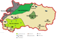
[[Fichier:Geo politique TH.gif|right|200px]] | [[Fichier:Geo politique TH.gif|right|200px]] | ||
| − | + | La cartographie au [[Thoulak]] est chargé de l’étude et la confection de carte du Thoulak. Créée par [[Metri]] en 2013, elle est reprise et nationalisée par [[Yeskiomach]] en Nov. 2016, dans le but de mettre les cartes à jour, et d'en créer pour l'[[URSS]]. | |
| − | + | ||
| − | La | + | |
| − | + | ||
| − | + | ||
Version du 10 novembre 2016 à 16:15
Entreprise Thoulakienne

| La Cartographie Thoulakienne | |
| Création | Juin 2013 |
|---|---|
| Dates clef | Juin 2013 (Fondation) Nov. 2016 (Reprise) |
| Fondateur | Metri |
| PDG Actuel | Yeskiomach |
| Slogan | - |
| Siège social | |
| Secteur d'activité | Cartographie |
| Oblasts représentés | 7 7 |
| Effectif | |
| Site web | Aucun |
| Chiffres d'affaire | Aucun |
| Résultats net | Aucuns |
| Siège de l'Entreprise | |

| |

La cartographie au Thoulak est chargé de l’étude et la confection de carte du Thoulak. Créée par Metri en 2013, elle est reprise et nationalisée par Yeskiomach en Nov. 2016, dans le but de mettre les cartes à jour, et d'en créer pour l'URSS.
Sommaire

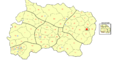
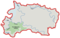
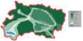
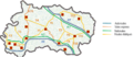
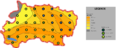
 Carte Administrative
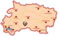
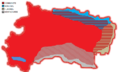
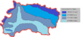
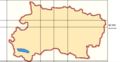
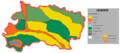
 Carte des oblasts du Thoulak (Oct. 2016)
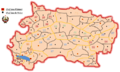
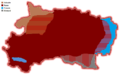
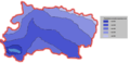
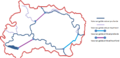
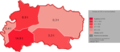
 Ancienne carte des oblasts du Thoulak
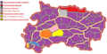
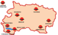
 Carte des Raions du Thoulak
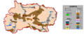
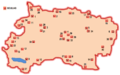 Carte des Goulags du Thoulak


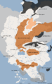
Carte Culturelle
 Carte répartition de la population du Thoulak
 Carte répartition des langues du Thoulak
 Carte style architecture du Thoulak
 Carte politique du Thoulak


Carte Géographique
 Carte Géographique du Thoulak
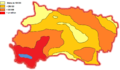
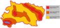
 Carte Temperature du Thoulak
 Carte Pluviométrie du Thoulak
 Carte climatique du Thoulak
 Carte hydrolique du Thoulak
 Carte forestière du Thoulak
 Carte des distances du Thoulak


Carte des Transports
 Carte Aeroport du Thoulak
 Carte réseau ferré du Thoulak
 Voie maritime du Thoulak
 Carte des routes du Thoulak


Carte Economique
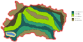
 Carte Agricole du Thoulak
 Carte des minéraux du Thoulak
 Carte activité économique du Thoulak
 Carte des ressources d'hydrocarbure de simland
 Carte fertilité des sol du Thoulak
 Carte émission de co2 du Thoulak
 Carte touristique du Thoulak


