Carthographie Thoulakienne : Différence entre versions
Un article de WikiSimland 3.0.
(→center|100px45pxCarte Economique) |
(→center|100px45pxCarte Culturelle) |
||
| Ligne 25: | Ligne 25: | ||
<gallery> | <gallery> | ||
Image:Repartition population th.png|[[Fichier:TCParms.gif|17px]] '''Carte répartition de la population''' | Image:Repartition population th.png|[[Fichier:TCParms.gif|17px]] '''Carte répartition de la population''' | ||
| + | Langue th metr.png|[[Fichier:TCParms.gif|17px]] '''Carte répartition des langues''' | ||
</gallery> | </gallery> | ||
Version du 5 juillet 2013 à 15:27

La carthographie au Thoulak est chargé de l'etude et la confection de carte du Thoulak .
Sommaire

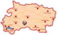
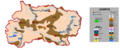
 Carte Administrative
 Carte des oblasts du Thoulak
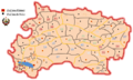 Carte des Raions du Thoulak


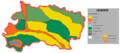
Carte Culturelle
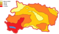 Carte répartition de la population
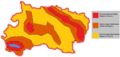
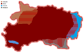 Carte répartition des langues


Carte Géographique
Carte des Transports
Carte Economique
 Carte Agricole du Thoulak
 Carte des minéraux du Thoulak
 Carte activité économique du Thoulak


