Modèle:Infobox Fed Simland : Différence entre versions
Un article de WikiSimland 3.0.
(Page créée avec « {| class="toccolours" style="float:right;margin: 0em 0em 0em 1em;" |- ! colspan="2" align="center" valign="middle" height="40" style="font-size: 1em; background: #5268f1;... ») |
M |
||
| Ligne 25: | Ligne 25: | ||
| style=" padding: 0.4em 1em 0.4em 0; vertical-align: top" | [[Sim Hurban]]<br>[[Yu Langlay]] | | style=" padding: 0.4em 1em 0.4em 0; vertical-align: top" | [[Sim Hurban]]<br>[[Yu Langlay]] | ||
|- | |- | ||
| − | ! style=" padding: 0.4em 1em 0.4em 0; vertical-align: top; text-align: left;" | <font color=#002d75>'''[[Langues à Simland|Langue officielle]]'''</font color> | + | ! style=" padding: 0.4em 1em 0.4em 0; vertical-align: top; text-align: left;" | <font color=#002d75>'''[[Langues à Simland|Langue officielle]]<br>[[Langues à Simland|Langue régionale]]'''</font color> |
| − | | style=" padding: 0.4em 1em 0.4em 0; vertical-align: top" | Français | + | | style=" padding: 0.4em 1em 0.4em 0; vertical-align: top" | Français<br>Anglais, Espagnol,<br>Hollandais, Russe |
|- | |- | ||
! style=" padding: 0.4em 1em 0.4em 0; vertical-align: top; text-align: left;" | <font color=#002d75>'''[[Capitale fédérale|Capitale]]'''</font color> | ! style=" padding: 0.4em 1em 0.4em 0; vertical-align: top; text-align: left;" | <font color=#002d75>'''[[Capitale fédérale|Capitale]]'''</font color> | ||
| − | | style=" padding: 0.4em 1em 0.4em 0; vertical-align: top" | [[Utopia]]<br><small> | + | | style=" padding: 0.4em 1em 0.4em 0; vertical-align: top" | [[Utopia]]<br><small>42°20'21.2"N 171°04'46.5"W</small> |
|- | |- | ||
! colspan="2" align="center" valign="middle" height="20" style="font-weight: bold; font-size: 1em; background: #5268f1; color: #ffffff" | <font size="2">'''Géographique''' | ! colspan="2" align="center" valign="middle" height="20" style="font-weight: bold; font-size: 1em; background: #5268f1; color: #ffffff" | <font size="2">'''Géographique''' | ||
| Ligne 47: | Ligne 47: | ||
! colspan="2" align="center" valign="middle" height="20" style="font-weight: bold; font-size: 1em; background: #5268f1; color: #ffffff" | <font size="2">'''Histoire''' | ! colspan="2" align="center" valign="middle" height="20" style="font-weight: bold; font-size: 1em; background: #5268f1; color: #ffffff" | <font size="2">'''Histoire''' | ||
|- | |- | ||
| − | ! style=" padding: 0.4em 1em 0.4em 0; vertical-align: top; text-align: left;" | <font color=#002d75>'''[[Traité d'unification]]'''</font color> | + | ! style=" padding: 0.4em 1em 0.4em 0; vertical-align: top; text-align: left;" | <font color=#002d75>'''[[Traité d'unification]]/<br>[[Fête Nationale|Formation]]'''</font color> |
| style=" padding: 0.4em 1em 0.4em 0; vertical-align: top" | ''26 décembre 2003'' | | style=" padding: 0.4em 1em 0.4em 0; vertical-align: top" | ''26 décembre 2003'' | ||
| − | |||
| − | |||
| − | |||
| − | |||
| − | |||
| − | |||
| − | |||
|- | |- | ||
! colspan="2" align="center" valign="middle" height="20" style="font-weight: bold; font-size: 1em; background: #5268f1; color: #ffffff" | <font size="2">'''Démographie''' | ! colspan="2" align="center" valign="middle" height="20" style="font-weight: bold; font-size: 1em; background: #5268f1; color: #ffffff" | <font size="2">'''Démographie''' | ||
| Ligne 63: | Ligne 56: | ||
|- | |- | ||
! style=" padding: 0.4em 1em 0.4em 0; vertical-align: top; text-align: left;" | <font color=#002d75>'''[[Population de Simland|Population]]'''</font color> | ! style=" padding: 0.4em 1em 0.4em 0; vertical-align: top; text-align: left;" | <font color=#002d75>'''[[Population de Simland|Population]]'''</font color> | ||
| − | | style=" padding: 0.4em 1em 0.4em 0; vertical-align: top" | ''' | + | | style=" padding: 0.4em 1em 0.4em 0; vertical-align: top" | ''' 132 596 830 ''' habitants<br>''LCN juillet 2017 '' |
|- | |- | ||
! style=" padding: 0.4em 1em 0.4em 0; vertical-align: top; text-align: left;" | <font color=#002d75>'''Densité'''</font color> | ! style=" padding: 0.4em 1em 0.4em 0; vertical-align: top; text-align: left;" | <font color=#002d75>'''Densité'''</font color> | ||
| − | | style=" padding: 0.4em 1em 0.4em 0; vertical-align: top" | ''' | + | | style=" padding: 0.4em 1em 0.4em 0; vertical-align: top" | '''31,67''' habitants au km² |
|- | |- | ||
! colspan="2" align="center" valign="middle" height="20" style="font-weight: bold; font-size: 1em; background: #5268f1; color: #ffffff" | <font size="2">'''Économie'''</font size> | ! colspan="2" align="center" valign="middle" height="20" style="font-weight: bold; font-size: 1em; background: #5268f1; color: #ffffff" | <font size="2">'''Économie'''</font size> | ||
Version du 5 août 2017 à 16:04
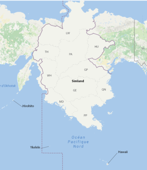
| Fédération de Simland (sd) | |
|---|---|
 | | 
| |

| |
| Devise Nationale | «Quand nos villes se rejoignent» |
| Hymne National | Sans titre |
| Administration | |
| Forme de l'État | République constitutionnelle présidentielle fédérale |
| Président Vice-Président |
Sim Hurban Yu Langlay |
| Langue officielle Langue régionale |
Français Anglais, Espagnol, Hollandais, Russe |
| Capitale | Utopia 42°20'21.2"N 171°04'46.5"W |
| Géographique | |
| Plus grande ville | Omega ville historique |
| Villes importantes | New Amsterdam Ckrystahal Medrean City Campton Vales |
| Superficie | 4 186 104 km² |
| Fuseaux Horaire | UTC -12 heure d'hiver UTC -11 heure d'été |
| Histoire | |
| Traité d'unification/ Formation |
26 décembre 2003 |
| Démographie | |
| Gentilé | Simlandais(e) |
| Population | 132 596 830 habitants LCN juillet 2017 |
| Densité | 31,67 habitants au km² |
| Économie | |
| PIB nominal | ... milliards USD |
| PIB par hab | ... USD |
| IDH | ... (très élevé) |
| Gini | ... (très élevé) |
| Monnaie | Simléon |
| Divers | |
| Code ISO 3161-2 | SIM |
| Domaine internet | .sd |
| Indicatif téléphonique | +17 |
| Forums Simland | |