Malde : Différence entre versions
(→Diversité ethnique) |
|||
| (107 révisions intermédiaires par 3 utilisateurs non affichées) | |||
| Ligne 1: | Ligne 1: | ||
{| class="toccolours" style="float:right;margin: 0em 0em 0em 1em;" | {| class="toccolours" style="float:right;margin: 0em 0em 0em 1em;" | ||
|- | |- | ||
| − | ! colspan="2" align="center" valign="middle" height="40" style="font-weight: bold; font-size: 1em; background: # | + | ! colspan="2" align="center" valign="middle" height="40" style="font-weight: bold; font-size: 1em; background: #356AA0; color: #ffffff" | <font size="4">'''Ville de Simland'''<br/> <font size="1">''Malde''</font size> |
|- | |- | ||
| − | | colspan="2" align="center" | [[Image:|320px]]<br> | + | | colspan="2" align="center" | [[Image:Malde.jpg|320px]]<br> |
|- | |- | ||
| − | ! colspan="2" align="center" valign="middle" height="20" style="font-weight: bold; font-size: 1em; background: # | + | ! colspan="2" align="center" valign="middle" height="20" style="font-weight: bold; font-size: 1em; background: #356AA0; color: #ffffff" | <font size="2">'''Administration''' |
|- | |- | ||
| − | | <font color=# | + | | <font color=#356AA0>'''Pays'''</font color> || align="center" | [[Simland]] [[Image:DrapSimlFlot.jpg|20px]] |
|- | |- | ||
| − | | <font color=# | + | | <font color=#356AA0>'''État'''</font color> || align="center" | '''[[Génésie]]''' ([[07]]) [[Image:Drapeau Génésie Moderne.JPG|31px]] |
|- | |- | ||
| − | | <font color=# | + | | <font color=#356AA0>'''District'''</font color> || align="center" | [[Génésie Centrale]] |
|- | |- | ||
| − | | <font color=# | + | | <font color=#356AA0>'''Comté'''</font color> || align="center" | [[Comté de Malde]] |
|- | |- | ||
| − | | <font color=# | + | | <font color=#356AA0>'''Quartiers'''</font color> || align="center" | [[24 Boroughs]] |
|- | |- | ||
| − | | <font color=# | + | | <font color=#356AA0>'''Maire'''</font color> || align="center" | [[Alexander Louis Davis]] ([[UDS (2012)|UDS]]) |
|- | |- | ||
| − | ! colspan="2" align="center" valign="middle" height="20" style="font-weight: bold; font-size: 1em; background: # | + | ! colspan="2" align="center" valign="middle" height="20" style="font-weight: bold; font-size: 1em; background: #356AA0; color: #ffffff" | <font size="2">'''Démographie''' |
|- | |- | ||
| − | | <font color=# | + | | <font color=#356AA0>'''Langues'''</font color> || align="center" | <small>Anglais ''(77%)'', Français ''(20%)'', Autres ''(3%)'' </small> |
|- | |- | ||
| − | |<font color=# | + | |<font color=#356AA0>'''Population'''</font color> || align="center" | 2.852.103. (agglo) / 820.603 (ville)(2014) |
|- | |- | ||
| − | |<font color=# | + | |<font color=#356AA0>'''Gentilé'''</font color>|| align="center" | ''Maldien, Maldienne'' |
|- | |- | ||
| − | |<font color=# | + | |<font color=#356AA0>'''Moyenne d'âge population'''</font color>|| align="center" | 31,5 ans |
|- | |- | ||
| − | ! colspan="2" align="center" valign="middle" height="20" style="font-weight: bold; font-size: 1em; background: # | + | ! colspan="2" align="center" valign="middle" height="20" style="font-weight: bold; font-size: 1em; background: #356AA0; color: #ffffff" | <font size="2">'''Infrastructures et transport''' |
|- | |- | ||
| − | |<font color=# | + | |<font color=#356AA0>'''Aéroport principal'''</font color>|| align="center" | [[Aérodrome John Smith - (projet aéroport en cours)]] |
|- | |- | ||
| − | |<font color=# | + | |<font color=#356AA0>'''Port principal'''</font color>|| align="center" | [[SeaPort Malde Génésia]] |
|- | |- | ||
| − | |<font color=# | + | |<font color=#356AA0>'''LRS et LGV'''</font color>|| align="center" style="font-size: 90%;" | [[LGV Est-Ouest]] - [[LRS Nord-Sud ]] |
|- | |- | ||
| − | |<font | + | ! colspan="2" align="center" valign="middle" height="20" style="font-weight: bold; font-size: 1em; background: #356AA0; color: #ffffff" | <font size="2">'''Géographie''' |
|- | |- | ||
| − | + | |<font color=#356AA0>'''Coordonées'''</font color>|| align="center" | 51°53'38.93"" Nord<br>176° 9'33.81"" Ouest | |
|- | |- | ||
| − | |<font color=# | + | |<font color=#356AA0>'''Superficie'''</font color>|| align="center" | 1 572 000 ha / 1 572km² |
|- | |- | ||
| − | |<font color=# | + | |<font color=#356AA0><small>'''Altitude'''</small></font color>|| align="center" | Min. 0 m – Max. 21 m |
|- | |- | ||
| − | + | |<font color=#356AA0>'''Fuseau Horaire'''</font color>|| align="center" | UTC - 12 | |
|- | |- | ||
| − | | colspan="2" align="center" |[[Image:| | + | ! colspan="2" align="center" valign="middle" height="20" style="font-weight: bold; font-size: 1em; background: #356AA0; color: #ffffff" | <font size="2">'''Divers''' |
| + | |- | ||
| + | |<font color=#356AA0>'''Fondation'''</font color>|| align="center" | Juin 1667 | ||
| + | |- | ||
| + | |<font color=#356AA0>'''Surnom'''</font color>|| align="center" | '' The New London'' / ''The City where all is possible'' | ||
| + | |- | ||
| + | ! colspan="2" align="center" valign="middle" height="20" style="font-weight: bold; font-size: 1em; background: #356AA0; color: #ffffff" | <font size="2">'''Localisation''' | ||
| + | |- | ||
| + | | colspan="2" align="center" |[[Image:Emplacementmalde.jpg|0px]] | ||
|} | |} | ||
| − | + | <div class="plainlinks"> | |
| + | {| class="messagebox current" style="width: auto;background: #ffdfc0;" | ||
| + | | [[Image:42px-Under_contruction_icon-yellow.gif]] | ||
| + | | '''Cette page est en cours d'écriture par [[TheVenger]]''' <br> <small>Merci de patienter, la version finale sera bientôt disponible !</small> | ||
| + | |} | ||
| + | |||
| + | Malde est située au centre de la [[Génésie]] et capitale de [[Génésie Supérieure]], est une ville de 820 603 habitants. | ||
| + | =Histoire= | ||
| + | ==Origine== | ||
| + | |||
| + | ==Les deux guerres mondiales(1900-1945)== | ||
| + | |||
| + | |||
| + | == Après-guerre et indépendance (1945-1961)== | ||
| + | |||
| + | |||
| + | ==Epoque Contemporaine (1961-....)== | ||
| + | |||
| + | |||
| + | =Administration et Quartiers= | ||
| + | ==Administration locale== | ||
| + | |||
| + | {|class="toccolours" style="margin:0 auto;background:none;" | ||
| + | |+'''Carte des 11 districts de Malde''' | ||
| + | |- | ||
| + | |<ol start="1"> | ||
| + | <li>Cité de Malde</li> | ||
| + | <li>Chelsington</li> | ||
| + | <li>Brookfield </li> | ||
| + | <li> Greenwich </li> | ||
| + | <li> Barrick </li> | ||
| + | <li> Chesterfield</li> | ||
| + | </ol> | ||
| + | |style="background:#FFF;padding:1em;" class="toccolours"|[[Fichier:Borough of Malde.jpg|600px]] | ||
| + | |<ol start="7"> | ||
| + | <li> Groomley</li> | ||
| + | <li> East Field</li> | ||
| + | <li>Hamptons</li> | ||
| + | <li>North End</li> | ||
| + | <li> Feltham</li> | ||
| + | |<ol start="1"> | ||
| + | |} | ||
| + | |||
| + | La ville est divisée en 11 quartiers chacun dirigée par un représentant de la mairie. Les quartiers les plus aisées sont [[Cité de Malde]] et [[Chelsington]] alors que les quartiers moins favorisés se trouvent principalement à la périphérie de la ville. | ||
| + | |||
| + | ==Jumelages== | ||
| + | |||
| + | La villes est jumelée avec [[Constancy]], Liverpool (UK), Lille (FRA), Lisbonne (POR) et Tanger (MAR) | ||
| + | |||
| + | =Démographie= | ||
| + | == Évolution de la Population== | ||
| + | |||
| + | {| | ||
| + | ! style="background:#efefef;" | Année | ||
| + | ! style="background:#efefef;" | Habitants | ||
| + | |----- | ||
| + | | 1700 || align="right" | {{formatnum:43541}} | ||
| + | |----- | ||
| + | | 1750 || align="right" | {{formatnum:54981}} | ||
| + | |----- | ||
| + | | 1800 || align="right" | {{formatnum:79765}} | ||
| + | |----- | ||
| + | | 1810 || align="right" | {{formatnum:84236}} | ||
| + | |----- | ||
| + | | 1820 || align="right" | {{formatnum:86243}} | ||
| + | |----- | ||
| + | | 1830 || align="right" | {{formatnum:88657}} | ||
| + | |----- | ||
| + | | 1840 || align="right" | {{formatnum:91324}} | ||
| + | |----- | ||
| + | | 1850 || align="right" | {{formatnum:92347}} | ||
| + | |----- | ||
| + | | 1860 || align="right" | {{formatnum:97645}} | ||
| + | |----- | ||
| + | | 1870 || align="right" | {{formatnum:110345}} | ||
| + | |----- | ||
| + | | 1880 || align="right" | {{formatnum:36734}} | ||
| + | |----- | ||
| + | | 1890 || align="right" | {{formatnum:28134}} | ||
| + | |----- | ||
| + | | 1900 || align="right" | {{formatnum:31982}} | ||
| + | |} | ||
| + | {| | ||
| + | ! style="background:#efefef;" | Année | ||
| + | ! style="background:#efefef;" | Habitants | ||
| + | |----- | ||
| + | | 1910 || align="right" | {{formatnum:36432}} | ||
| + | |----- | ||
| + | | 1920 || align="right" | {{formatnum:35486}} | ||
| + | |----- | ||
| + | | 1930 || align="right" | {{formatnum:38198}} | ||
| + | |----- | ||
| + | | 1940 || align="right" | {{formatnum:40873}} | ||
| + | |----- | ||
| + | | 1950 || align="right" | {{formatnum:39234}} | ||
| + | |----- | ||
| + | | 1960 || align="right" | {{formatnum:43657}} | ||
| + | |----- | ||
| + | | 1970 || align="right" | {{formatnum:47895}} | ||
| + | |----- | ||
| + | | 1980 || align="right" | {{formatnum:45543}} | ||
| + | |----- | ||
| + | | 1990 || align="right" | {{formatnum:49670}} | ||
| + | |----- | ||
| + | | 2000 || align="right" | {{formatnum:57342}} | ||
| + | |----- | ||
| + | | 2014 || align="right"| {{formatnum:62603}} | ||
| + | |} | ||
| + | |||
| + | ==Diversité ethnique== | ||
| + | |||
| + | <div style="font-size: 90%"> | ||
| + | {| class="wikitable" style="border:1px black; float:right; margin-left:1em;" | ||
| + | |- | ||
| + | ! style="background:#f99;" colspan="2"|Groupe ethnique (2014) | ||
| + | |- | ||
| + | |[[Blanc (humain)|Blanc]]||51,8 % | ||
| + | |- | ||
| + | |[[Noir (humain)|Noir]]||27,2 % | ||
| + | |- | ||
| + | |[[Asiatique (humain)|Asiatique]]||13,3 % | ||
| + | |- | ||
| + | |[[Métis]] ou autres||8,7% | ||
| + | |}</div> | ||
| + | |||
| + | {| class="wikitable gauche" | ||
| + | |+ | ||
| + | ! Pays de naissance || Population<br />en 2014 | ||
| + | |- | ||
| + | | Simland {{SIM}} ||align=right | {{formatnum:38000}} | ||
| + | |- | ||
| + | | Royaume-Uni [[Image:Royaume.Uni.png|20px]]||align=right | {{formatnum:13000}} | ||
| + | |- | ||
| + | | France [[Image:FRANCE.jpg|20px]] ||align=right | {{formatnum:8500}} | ||
| + | |- | ||
| + | | États-Unis [[Image:USA.png|20px]] ||align=right | {{formatnum:1590}} | ||
| + | |- | ||
| + | | Italie [[Image:Italie.jpg|20px]] ||align=right | {{formatnum:1300}} | ||
| + | |- | ||
| + | | Turquie [[Image:Turquie.png|20px]] ||align=right | {{formatnum:1200}} | ||
| + | |- | ||
| + | | Allemagne [[Image:ALLEMAGNE.jpg|20px]] ||align=right | {{formatnum:913}} | ||
| + | |- | ||
| + | |} | ||
| + | |||
| + | La force de la ville est sa grande diversité ethnique, composée en majorité d'habitants natifs du Royaume-Uni descendants des colons anglais. Il y a également des habitants originaires de Turquie, Italie, Allemagne, États-Unis, France et bien sûr de Simland. La religion majoritaire est le christianisme suivit de près par l'islam. La ville est composée en majorités de "blancs" mais la politique sociale et d'intégration à fait augmenter les population "noirs" et "métisses" de 82% depuis l'an 2000. | ||
| + | |||
| + | ==Résidents nées à l'étranger== | ||
| + | |||
| + | =Géographie et Climat= | ||
| + | |||
| + | ==Géographie== | ||
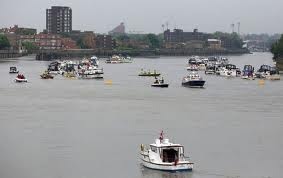
| + | [[Image:StGeorges.jpg|350px|thumb|left|Bateaux sur le fleuve St.Georges]] | ||
| + | |||
| + | ==Climat== | ||
| + | |||
| + | {|width="100%" class="wikitable" style="text-align:center;" | ||
| + | |+style="font-weight: bold; font-size: 1.1em; margin-bottom: 0.5em"| Climatologie de Malde | ||
| + | !style="text-align:center"|Mois!!Janv!!Fév!!Mars!!Avr!!Mai!!Juin!!Juil!!Août!!Sept!!Oct!!Nov!!Déc!!Année | ||
| + | |- | ||
| + | !style="text-align:left"|Températures minimales moyennes (°C) | ||
| + | |style="background:#d0ebdb"|-1 | ||
| + | |style="background:#fbffd5"|-2 | ||
| + | |style="background:#fcfbc6"|4 | ||
| + | |style="background:#fdfac1"|6 | ||
| + | |style="background:#fdf2a4"|7 | ||
| + | |style="background:#fae98a"|8 | ||
| + | |style="background:#f6dc61"|10 | ||
| + | |style="background:#f9e47c"|11 | ||
| + | |style="background:#fbed97"|15 | ||
| + | |style="background:#fef7b7"|13 | ||
| + | |style="background:#fcfccb"|9 | ||
| + | |style="background:#dff2d9"|4 | ||
| + | |style="background:#fdfac1"|7 | ||
| + | |- | ||
| + | !style="text-align:left"|Températures moyennes (°C) | ||
| + | |style="background:#fbfed0"|0 | ||
| + | |style="background:#fdfac1"|4 | ||
| + | |style="background:#fdf2a4"|8 | ||
| + | |style="background:#fae98a"|10 | ||
| + | |style="background:#f6dc61"|13 | ||
| + | |style="background:#f2cf39"|16 | ||
| + | |style="background:#edb722"|19 | ||
| + | |style="background:#f1ca2b"|25 | ||
| + | |style="background:#f2cf39"|18 | ||
| + | |style="background:#f6dc61"|14 | ||
| + | |style="background:#fef7b7"|11 | ||
| + | |style="background:#fcfccb"|7 | ||
| + | |style="background:#fae98a"|12 | ||
| + | |- | ||
| + | !style="text-align:left"|Températures maximales moyennes (°C) | ||
| + | |style="background:#fdfac1"|5 | ||
| + | |style="background:#fdf2a4"|8 | ||
| + | |style="background:#f7e06e"|15 | ||
| + | |style="background:#f3d347"|17 | ||
| + | |style="background:#efc324"|21 | ||
| + | |style="background:#e6961b"|25 | ||
| + | |style="background:#e28017"|28 | ||
| + | |style="background:#e48b19"|32 | ||
| + | |style="background:#f1ca2b"|29 | ||
| + | |style="background:#f6dc61"|23 | ||
| + | |style="background:#fbed97"|15 | ||
| + | |style="background:#fef7b7"|13 | ||
| + | |style="background:#f5d754"|19,25 | ||
| + | |- | ||
| + | !style="text-align:left"|Précipitations mensuelles moyennes (mm) | ||
| + | |style="background:#0565b7"|<font color=white>81</font> | ||
| + | |style="background:#0772c1"|<font color=white>69</font> | ||
| + | |style="background:#0c8ed6"|55 | ||
| + | |style="background:#10aaea"|43 | ||
| + | |style="background:#13b7f5"|31 | ||
| + | |style="background:#15c5ff"|19 | ||
| + | |style="background:#3cd3ff"|5 | ||
| + | |style="background:#15c5ff"|52 | ||
| + | |style="background:#0e9ce0"|11 | ||
| + | |style="background:#0980cb"|<font color=white>22</font> | ||
| + | |style="background:#0772c1"|<font color=white>42</font> | ||
| + | |style="background:#0257ac"|<font color=white>79</font> | ||
| + | |style="background:#002948"|<font color=white>509</font> | ||
| + | |} | ||
| + | |||
| + | Le climat de Malde est continental, relativement doux avec une assez faible pluviométrie. L'été est assez calme avec un mois de juillet plutôt doux aux niveaux des température et faible en pluviométrie alors que le mois d'Août est un mois pluvieux et chaud. | ||
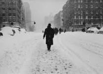
| + | [[Image:Neige.jpg|350px|thumb|lef|Rues de Malde en 1954 durant la vague de froid]] | ||
| + | |||
| + | ==Risques Climatiques et géographiques== | ||
| + | |||
| + | ===Risques de Crue=== | ||
| + | |||
| + | ==Quartiers== | ||
| + | |||
| + | ==Urbanisation== | ||
| + | |||
| + | =Transports= | ||
| + | |||
| + | ==Transports ferroviaires== | ||
| + | |||
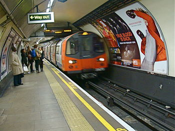
| + | [[Image:Métromalde.jpg|350px|thumb|right|Métro de Malde à la station de Chelsington]] | ||
| + | |||
| + | =Économie= | ||
| + | |||
| + | ==Attractivité== | ||
| + | |||
| + | ==Tourisme== | ||
| + | |||
| + | =Média= | ||
| + | |||
| + | =Sécurité= | ||
| + | |||
| + | ==Police== | ||
| + | |||
| + | =Autres= | ||
| + | |||
| + | <br clear="all"> | ||
| + | <center> | ||
| + | {|class="toccolours" style="margin: 0 2em 0 2em;" | ||
| + | | [[Image:Malde.jpg | 160px]] | ||
| + | ! style="background:#356AA0" align="center" width="100%" | <span; style="font-weight: ; font-size: 1.5em; color:#ffffff"> Ville de Malde </span> | ||
| + | | [[Image:UNITED KINGDOM.jpg | 120px]] | ||
| + | |- | ||
| + | | | ||
| + | !align= "center" | <big>'''Transports'''</big> <br> [[Métro de Malde]] • [[Aéroport de Malde]] • [[Transports en communs de Malde]] | ||
| + | ---- | ||
| + | |- | ||
| + | | | ||
| + | !align="center" | <big>'''Quartiers de Malde'''</big> <br> [[Cité de Malde]] • [[Chelsington]] • [[Brookfield]] • [[Barrick]] • [[Hamptons]] • [[Chesterfield]] • [[Groomley]] • [[Greenwich]] | ||
| + | ---- | ||
| + | |- | ||
| + | | | ||
| + | !align= "center" | <big>'''Personnalités'''</big> <br> [[Alexander Louis Davis]] • [[John Smith]] | ||
| + | ---- | ||
| + | |- | ||
| + | | | ||
| + | !align= "center" | <big>'''Lieux importants et monuments'''</big> <br> [[Palais des Anglais]] • [[Tour de l'horloge ]] | ||
| + | ---- | ||
| + | |- | ||
| + | | | ||
| + | !align="center" | <big>'''Sports'''</big> <br> [[Blue Birds]] • [[TD Garden]] • [[Stade de Malde]] • [[John Smith Stadium]] • [[Malde Eagles]] • [[Malde City FC]] | ||
| + | |} | ||
| + | </center> | ||
| + | |||
| + | |||
| + | {{Lien Villes de Génésie}} | ||
Version actuelle en date du 15 janvier 2017 à 15:00
| Ville de Simland Malde | |
|---|---|
 | |
| Administration | |
| Pays | Simland |
| État | Génésie (07) |
| District | Génésie Centrale |
| Comté | Comté de Malde |
| Quartiers | 24 Boroughs |
| Maire | Alexander Louis Davis (UDS) |
| Démographie | |
| Langues | Anglais (77%), Français (20%), Autres (3%) |
| Population | 2.852.103. (agglo) / 820.603 (ville)(2014) |
| Gentilé | Maldien, Maldienne |
| Moyenne d'âge population | 31,5 ans |
| Infrastructures et transport | |
| Aéroport principal | Aérodrome John Smith - (projet aéroport en cours) |
| Port principal | SeaPort Malde Génésia |
| LRS et LGV | LGV Est-Ouest - LRS Nord-Sud |
| Géographie | |
| Coordonées | 51°53'38.93"" Nord 176° 9'33.81"" Ouest |
| Superficie | 1 572 000 ha / 1 572km² |
| Altitude | Min. 0 m – Max. 21 m |
| Fuseau Horaire | UTC - 12 |
| Divers | |
| Fondation | Juin 1667 |
| Surnom | The New London / The City where all is possible |
| Localisation | |
| |
Malde est située au centre de la Génésie et capitale de Génésie Supérieure, est une ville de 820 603 habitants.
Sommaire
[masquer]Histoire
Origine
Les deux guerres mondiales(1900-1945)
Après-guerre et indépendance (1945-1961)
Epoque Contemporaine (1961-....)
Administration et Quartiers
Administration locale
|
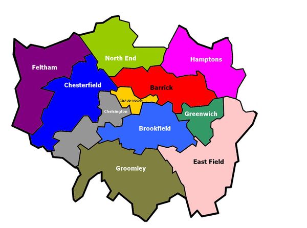
|
|
La ville est divisée en 11 quartiers chacun dirigée par un représentant de la mairie. Les quartiers les plus aisées sont Cité de Malde et Chelsington alors que les quartiers moins favorisés se trouvent principalement à la périphérie de la ville.
Jumelages
La villes est jumelée avec Constancy, Liverpool (UK), Lille (FRA), Lisbonne (POR) et Tanger (MAR)
Démographie
Évolution de la Population
| Année | Habitants |
|---|---|
| 1700 | 43 541 |
| 1750 | 54 981 |
| 1800 | 79 765 |
| 1810 | 84 236 |
| 1820 | 86 243 |
| 1830 | 88 657 |
| 1840 | 91 324 |
| 1850 | 92 347 |
| 1860 | 97 645 |
| 1870 | 110 345 |
| 1880 | 36 734 |
| 1890 | 28 134 |
| 1900 | 31 982 |
| Année | Habitants |
|---|---|
| 1910 | 36 432 |
| 1920 | 35 486 |
| 1930 | 38 198 |
| 1940 | 40 873 |
| 1950 | 39 234 |
| 1960 | 43 657 |
| 1970 | 47 895 |
| 1980 | 45 543 |
| 1990 | 49 670 |
| 2000 | 57 342 |
| 2014 | 62 603 |
Diversité ethnique
| Pays de naissance | Population en 2014 |
|---|---|
| Simland |
38 000 |
| Royaume-Uni |
13 000 |
| France |
8 500 |
| États-Unis |
1 590 |
| Italie |
1 300 |
| Turquie |
1 200 |
| Allemagne |
913 |
La force de la ville est sa grande diversité ethnique, composée en majorité d'habitants natifs du Royaume-Uni descendants des colons anglais. Il y a également des habitants originaires de Turquie, Italie, Allemagne, États-Unis, France et bien sûr de Simland. La religion majoritaire est le christianisme suivit de près par l'islam. La ville est composée en majorités de "blancs" mais la politique sociale et d'intégration à fait augmenter les population "noirs" et "métisses" de 82% depuis l'an 2000.
Résidents nées à l'étranger
Géographie et Climat
Géographie
Climat
| Mois | Janv | Fév | Mars | Avr | Mai | Juin | Juil | Août | Sept | Oct | Nov | Déc | Année |
|---|---|---|---|---|---|---|---|---|---|---|---|---|---|
| Températures minimales moyennes (°C) | -1 | -2 | 4 | 6 | 7 | 8 | 10 | 11 | 15 | 13 | 9 | 4 | 7 |
| Températures moyennes (°C) | 0 | 4 | 8 | 10 | 13 | 16 | 19 | 25 | 18 | 14 | 11 | 7 | 12 |
| Températures maximales moyennes (°C) | 5 | 8 | 15 | 17 | 21 | 25 | 28 | 32 | 29 | 23 | 15 | 13 | 19,25 |
| Précipitations mensuelles moyennes (mm) | 81 | 69 | 55 | 43 | 31 | 19 | 5 | 52 | 11 | 22 | 42 | 79 | 509 |
Le climat de Malde est continental, relativement doux avec une assez faible pluviométrie. L'été est assez calme avec un mois de juillet plutôt doux aux niveaux des température et faible en pluviométrie alors que le mois d'Août est un mois pluvieux et chaud.
Risques Climatiques et géographiques
Risques de Crue
Quartiers
Urbanisation
Transports
Transports ferroviaires
Économie
Attractivité
Tourisme
Média
Sécurité
Police
Autres

|
<span; style="font-weight: ; font-size: 1.5em; color:#ffffff"> Ville de Malde </span> | 
|
|---|---|---|
| Transports Métro de Malde • Aéroport de Malde • Transports en communs de Malde | ||
| Quartiers de Malde Cité de Malde • Chelsington • Brookfield • Barrick • Hamptons • Chesterfield • Groomley • Greenwich | ||
| Personnalités Alexander Louis Davis • John Smith | ||
| Lieux importants et monuments Palais des Anglais • Tour de l'horloge | ||
| Sports Blue Birds • TD Garden • Stade de Malde • John Smith Stadium • Malde Eagles • Malde City FC |
| Villes de Génésie | |
|---|---|
| Oakdale • Armor • Bay City • Berneuil • Carlossane • Columbia 3000 • Giant Bay • Hustines • Malde • Minéapolis/Shadows • Naules • Paname • Patalia • Pyrtal • Saint Ignace • Saint-Servin • Sonoma • Windhoek |
