Canton d'Hochsberg : Différence entre versions
Un article de WikiSimland 3.0.
| Ligne 12: | Ligne 12: | ||
|<font color=#004080>'''Population'''</font color> || align="center" | ????hab | |<font color=#004080>'''Population'''</font color> || align="center" | ????hab | ||
|- | |- | ||
| − | |<font color=#004080>'''Villes importantes'''</font color> || align="center" | '''[[Klaw]], [[Hydrienstein]], [[ | + | |<font color=#004080>'''Villes importantes'''</font color> || align="center" | '''[[Klaw]], [[Hydrienstein]], [[Klörnerwald ]]''' |
|- | |- | ||
! colspan="2" align="center" valign="middle" height="20" style="font-weight: bold; font-size: 1em; background: #004080; color: #ffffff" | <font size="2">'''Situation Géographique'''</font size> | ! colspan="2" align="center" valign="middle" height="20" style="font-weight: bold; font-size: 1em; background: #004080; color: #ffffff" | <font size="2">'''Situation Géographique'''</font size> | ||
| Ligne 32: | Ligne 32: | ||
=Environnement= | =Environnement= | ||
| + | |||
| + | |||
| + | [[Modèle:cantonwham]] | ||
| + | [[Catégorie:Whamphalie]] | ||
Version du 4 octobre 2016 à 19:43
| Canton d'Hochsberg | |
|---|---|
| Drapeau | 
|
| Chef-lieu | Klaw |
| Gentilé | Hochsbergeois |
| Population | ????hab |
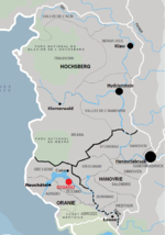
| Villes importantes | Klaw, Hydrienstein, Klörnerwald |
| Situation Géographique | |
| Localisation | 
|