Wakashima : Différence entre versions
Un article de WikiSimland 3.0.
M |
|||
| Ligne 13: | Ligne 13: | ||
| <font color=#801818>'''Département'''</font color> || align="center" | [[Hirohito]] [[Image:...|20px]] | | <font color=#801818>'''Département'''</font color> || align="center" | [[Hirohito]] [[Image:...|20px]] | ||
|- | |- | ||
| − | | <font color=#801818>'''Code postal'''</font color> || align="center" | | + | | <font color=#801818>'''Code postal'''</font color> || align="center" | 08 000 - 08 099 |
|- | |- | ||
| − | | <font color=#801818>'''Maire'''</font color> || align="center" | [[Columbo]] - [[RPD]] | + | | <font color=#801818>'''Maire'''</font color> || align="center" | [[Columbo]] - [[RPD]] - [[UPM]] |
|- | |- | ||
|<font color=#801818>'''Villes jumelées'''</font color>|| align="center" align="center" style="font-size: 90%;" | ... | |<font color=#801818>'''Villes jumelées'''</font color>|| align="center" align="center" style="font-size: 90%;" | ... | ||
|- | |- | ||
| − | | <font color=#801818>'''Site web'''</font color> || align="center" | [http://www.simland. | + | | <font color=#801818>'''Site web'''</font color> || align="center" | [http://www.simland.eu/forum/simland-meridional/wakashima-adachi-partie-t15881.html Topic de la ville] |
|- | |- | ||
! colspan="2" align="center" valign="middle" height="20" style="font-weight: bold; font-size: 1em; background: #095228; color: #ffffff" | <font size="2">'''Démographie''' | ! colspan="2" align="center" valign="middle" height="20" style="font-weight: bold; font-size: 1em; background: #095228; color: #ffffff" | <font size="2">'''Démographie''' | ||
|- | |- | ||
| − | |<font color=#801818>'''Population'''</font color>|| align="center" | ''' | + | |<font color=#801818>'''Population'''</font color>|| align="center" | '''82 000''' hab. |
|- | |- | ||
|<font color=#801818>'''Densité'''</font color> || align="center" | '''...''' hab. au km² | |<font color=#801818>'''Densité'''</font color> || align="center" | '''...''' hab. au km² | ||
| Ligne 49: | Ligne 49: | ||
|<font color=#801818>'''Localisation'''</font color> || align="center" | | |<font color=#801818>'''Localisation'''</font color> || align="center" | | ||
|- | |- | ||
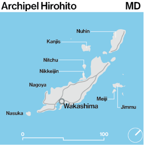
| − | ! colspan="2" align="center" |[[Fichier:. | + | ! colspan="2" align="center" |[[Fichier:Hirohitomap.png|300px]] |
|} | |} | ||
{{VillesSD}} | {{VillesSD}} | ||
Version du 22 avril 2014 à 07:20
| Wakashima ... | |
|---|---|
| ... | |
| Administration | |
| Pays | Simland |
| État | Méridionie |
| Département | Hirohito 20px |
| Code postal | 08 000 - 08 099 |
| Maire | Columbo - RPD - UPM |
| Villes jumelées | ... |
| Site web | Topic de la ville |
| Démographie | |
| Population | 82 000 hab. |
| Densité | ... hab. au km² |
| Gentillé | ..., ... |
| Economie | |
| Budget 2012 | ... |
| PIB | ... net/hab. |
| Taux de chômage | ...% |
| Université | ... - ... étudiants |
| Aéroport | ... |
| Géographie | |
| Altitude | ... mètres |
| Superficie | ... km² |
| Localisation | |

| |
| |
Ville de Méridionie | |
|---|---|---|
| Ville historique : | Assuria • Lostande Flor • Omega | |
| Ville active : | Ckrystahal • Heiwashima • Medrean City • Simwood • Sutton • Waheidaitoshi | |
| Ville ancienne : | Akalina • Akasaki • Antami • Antaria • Apoline • Apoltica • Apoltipolis • Arrandale • Beaufort la Nouvelle • Doramas • Eslandias • Fairview • Fukuota • Harlan • Hitoshinpû • Hunrise • Izumo • Kalos • Kamitoshi • La Crescenta-Montrose • Leikle • Los Apaches • Lybria • Mariobar • Mataro • Mérydile • Montisims • Moquannes • Neverland • Northmound • New Clark City • Nouvelle-Espérance • Palmiere • Pineview • Réaumur • Saint-Artis-en-Canyon • San Vergara • Scrinder • Sloaps • Soutnay • Springfield • Talgin Town • Tanaziof • Tarbonne • Technopolis • Terra Nova • Tossa Blanca • Tha Bay • Venitias • Wakashima • Westfield • Zoeltendam |