Port International de Santa Maria : Différence entre versions
Un article de WikiSimland 3.0.
M |
M |
||
| Ligne 1: | Ligne 1: | ||
| − | { | + | {| class="toccolours" style="float:right;margin: 0em 0em 0em 0em;" |
| − | | | + | |- |
| − | | | + | | colspan="2" align="center" | <big><big><b>Port of Santa Maria</b></big></big> <br> [[Fichier:PortofSantaMaria01.png|310px|Le Port de Santa Maria]] <br> [[Fichier:Portofsantamariaautority.png|310px|Port of Santa Maria Authority]] |
| − | | | + | |- |
| − | | | + | ! colspan="2" align="center" valign="middle" height="20" style="font-weight: bold; font-size: 1em; background: #060046; color: #ffffff" | <font size="2">'''Localisation''' |
| − | | | + | |- |
| − | | | + | | '''Pays''' || align="center" | [[Simland]] [[Image:drapeausimland_ico.jpg]] |
| − | + | |- | |
| + | | '''État''' || align="center" | [[Papaya]] [[Fichier:Papayadrapeau.jpg|25px]] | ||
| + | |- | ||
| + | | colspan="2" align="center" | [[Fichier:SantaMariaLocalisation.png|310px|Localisation du Port]] | ||
| + | |- | ||
| + | ! colspan="2" align="center" valign="middle" height="20" style="font-weight: bold; font-size: 1em; background: #060046; color: #ffffff" | <font size="2">'''Détails''' | ||
| + | |- | ||
| + | | '''Fondation''' || align="center" | 1667 | ||
| + | |- | ||
| + | | '''Taille du port''' || align="center" | 1,460 ha | ||
| + | |- | ||
| + | | '''Taille (zone industrielle)''' || align="center" | 3,000 ha | ||
| + | |- | ||
| + | | '''Quais''' || align="center" | 250 | ||
| + | |- | ||
| + | | '''Administrateur''' || align="center" | Port of Santa Maria Authority | ||
| + | |- | ||
| + | | '''Executive director''' || align="center" | Charles Nolan | ||
| + | |- | ||
| + | | '''Président''' || align="center" | William Loyd, Earl of Wheeland | ||
| + | |- | ||
| + | | '''Commissaires''' || align="center" | Martha Lindenberg <br> Erik Strauss <br> Rowan Atkins | ||
| + | |- | ||
| + | ! colspan="2" align="center" valign="middle" height="20" style="font-weight: bold; font-size: 1em; background: #060046; color: #ffffff" | <font size="2">'''Statistiques''' | ||
| + | |- | ||
| + | | '''Fréquentation''' || align="center" | 2,036 bâteaux (2011) | ||
| + | |- | ||
| + | | '''Tonnage annuel''' || align="center" | 154 Mt | ||
| + | |- | ||
| + | | '''Volume annuel''' || align="center" | 7,5 MTEU (eq conteneur) | ||
| + | |- | ||
| + | | '''Valeurs des marchandises''' || align="center" | US$213 milliards (2013) | ||
| + | |- | ||
| + | | '''Trafic domestique annuel''' || align="center" | 360 millions de passagers | ||
| + | |- | ||
| + | | '''Revenu annuel''' || align="center" | US$360 millions | ||
| + | |- | ||
| + | ! colspan="2" align="center" |<br><br>[[Fichier:Port of SantaMariaAncre.png|100px]] | ||
| + | |} | ||
{{Modif}} | {{Modif}} | ||
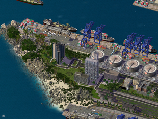
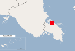
| − | Le <b>Port International de Santa Maria</b> est un | + | Le <b>Port International de Santa Maria</b> également désigné sous l'appelation '''Port of Santa Maria Authority''' (officiellement : ''eng'' : Port of Santa Maria Wheeland / ''fr'' : Port de Santa Maria Wheeland) est un complexe portuaire occupant 3,000 ha pour 68 km de front marin. Le port est localisé principalement au Nord de [[Santa Maria]] dans le district industriel de Wheeland, approximativement à 40 km au nord du Financial District de Santa Maria. Le port de Santa Maria emploie plus de 15,000 personnes, et est le plus important port d'exportation de [[Simland]]. |
| − | + | ||
| − | + | ||
| − | + | ||
| − | + | ||
| − | + | ||
| − | + | ||
| − | + | ||
| − | + | ||
| − | + | ||
| − | + | ||
| − | + | ||
| − | + | ||
| − | + | ||
| − | + | ||
| − | + | ||
| − | + | ||
| − | + | ||
| − | + | ||
| − | + | ||
Version du 30 avril 2014 à 10:10
Port of Santa Maria  | |
| Localisation | |
|---|---|
| Pays | Simland |
| État | Papaya |

| |
| Détails | |
| Fondation | 1667 |
| Taille du port | 1,460 ha |
| Taille (zone industrielle) | 3,000 ha |
| Quais | 250 |
| Administrateur | Port of Santa Maria Authority |
| Executive director | Charles Nolan |
| Président | William Loyd, Earl of Wheeland |
| Commissaires | Martha Lindenberg Erik Strauss Rowan Atkins |
| Statistiques | |
| Fréquentation | 2,036 bâteaux (2011) |
| Tonnage annuel | 154 Mt |
| Volume annuel | 7,5 MTEU (eq conteneur) |
| Valeurs des marchandises | US$213 milliards (2013) |
| Trafic domestique annuel | 360 millions de passagers |
| Revenu annuel | US$360 millions |

| |
Le Port International de Santa Maria également désigné sous l'appelation Port of Santa Maria Authority (officiellement : eng : Port of Santa Maria Wheeland / fr : Port de Santa Maria Wheeland) est un complexe portuaire occupant 3,000 ha pour 68 km de front marin. Le port est localisé principalement au Nord de Santa Maria dans le district industriel de Wheeland, approximativement à 40 km au nord du Financial District de Santa Maria. Le port de Santa Maria emploie plus de 15,000 personnes, et est le plus important port d'exportation de Simland.
| <span; style="font-weight: ; font-size: 1.0em; color: #ffffff ">Transports du Mercent</span> | | |
|---|---|---|
| Gare Mercentille - King George VI | ||
| Aéroports Mercentille - William J. Clinton International • Aéroport International de Santa Maria | ||
| Ports Portheaven Harbour • Port International de Santa Maria | ||

|