Autoroutes nationales : Différence entre versions
Un article de WikiSimland 3.0.
(→Tableau) |
(→Tableau) |
||
| Ligne 30: | Ligne 30: | ||
! scope="col" | Longueur | ! scope="col" | Longueur | ||
|- | |- | ||
| − | | [[ | + | | [[image:Au1.jpg|70px]] |
! scope="row" style="font-weight: bold;" | [[Autoroute A1|A1]] | ! scope="row" style="font-weight: bold;" | [[Autoroute A1|A1]] | ||
| Nord-Sud | | Nord-Sud | ||
| Ligne 37: | Ligne 37: | ||
|align="center"| 3000km | |align="center"| 3000km | ||
|- | |- | ||
| − | | [[Image: | + | | [[Image:Au2.jpg|70px]] |
! scope="row" style="font-weight: bold;" | [[Autoroute A2|A2]] | ! scope="row" style="font-weight: bold;" | [[Autoroute A2|A2]] | ||
| Nord-Sud | | Nord-Sud | ||
| Ligne 44: | Ligne 44: | ||
|align="center"| 2500km | |align="center"| 2500km | ||
|- | |- | ||
| − | | [[Image: | + | | [[Image:Au3.jpg|70px]] |
! scope="row" style="font-weight: bold;" | [[Autoroute A3|A3]] | ! scope="row" style="font-weight: bold;" | [[Autoroute A3|A3]] | ||
| Nord-Sud | | Nord-Sud | ||
| Ligne 51: | Ligne 51: | ||
|align="center"| 3200km | |align="center"| 3200km | ||
|- | |- | ||
| − | | [[Image: | + | | [[Image:Au4.jpg|70px]] |
! scope="row" style="font-weight: bold;" | [[Autoroute A4|A4]] | ! scope="row" style="font-weight: bold;" | [[Autoroute A4|A4]] | ||
| Est-Ouest | | Est-Ouest | ||
| Ligne 58: | Ligne 58: | ||
|align="center"| 1000km | |align="center"| 1000km | ||
|- | |- | ||
| − | | [[Image: | + | | [[Image:Au5.jpg|70px]] |
! scope="row" style="font-weight: bold;" | [[Autoroute A5|A5]] | ! scope="row" style="font-weight: bold;" | [[Autoroute A5|A5]] | ||
| Est-Ouest | | Est-Ouest | ||
| Ligne 65: | Ligne 65: | ||
|align="center"| 750km | |align="center"| 750km | ||
|- | |- | ||
| − | | [[Image: | + | | [[Image:Au6.jpg|70px]] |
! scope="row" style="font-weight: bold;" | [[Autoroute A6|A6]] | ! scope="row" style="font-weight: bold;" | [[Autoroute A6|A6]] | ||
| Est-Ouest | | Est-Ouest | ||
| Ligne 72: | Ligne 72: | ||
|align="center"| 600km | |align="center"| 600km | ||
|- | |- | ||
| − | | [[Image: | + | | [[Image:Au7.jpg|70px]] |
! scope="row" style="font-weight: bold;" | [[Autoroute A7|A7]] | ! scope="row" style="font-weight: bold;" | [[Autoroute A7|A7]] | ||
| Nord-Sud | | Nord-Sud | ||
| Ligne 79: | Ligne 79: | ||
|align="center"| 1250km | |align="center"| 1250km | ||
|- | |- | ||
| − | | [[Image: | + | | [[Image:A10.jpg|70px]] |
! scope="row" style="font-weight: bold;" | [[Autoroute A10|A10]] | ! scope="row" style="font-weight: bold;" | [[Autoroute A10|A10]] | ||
| Nord-Sud | | Nord-Sud | ||
| Ligne 86: | Ligne 86: | ||
|align="center"| 75km | |align="center"| 75km | ||
|- | |- | ||
| − | | [[Image: | + | | [[Image:A20.jpg|70px]] |
! scope="row" style="font-weight: bold;" | [[Autoroute A20|A20]] | ! scope="row" style="font-weight: bold;" | [[Autoroute A20|A20]] | ||
| Est-Ouest | | Est-Ouest | ||
| Ligne 93: | Ligne 93: | ||
|align="center"| 400km | |align="center"| 400km | ||
|- | |- | ||
| − | | [[Image: | + | | [[Image:A23.jpg|70px]] |
! scope="row" style="font-weight: bold;" | [[Autoroute A23|A23]] | ! scope="row" style="font-weight: bold;" | [[Autoroute A23|A23]] | ||
| Est-Ouest | | Est-Ouest | ||
| Ligne 100: | Ligne 100: | ||
|align="center"| 1100km | |align="center"| 1100km | ||
|- | |- | ||
| − | | [[Image: | + | | [[Image:A26.jpg|70px]] |
! scope="row" style="font-weight: bold;" | [[Autoroute A26|A26]] | ! scope="row" style="font-weight: bold;" | [[Autoroute A26|A26]] | ||
| Est-Ouest | | Est-Ouest | ||
| Ligne 107: | Ligne 107: | ||
|align="center"| 250km | |align="center"| 250km | ||
|- | |- | ||
| − | | [[Image: | + | | [[Image:A33.jpg|70px]] |
! scope="row" style="font-weight: bold;" | [[Autoroute A33|A33]] | ! scope="row" style="font-weight: bold;" | [[Autoroute A33|A33]] | ||
| Nord-Sud | | Nord-Sud | ||
| Ligne 114: | Ligne 114: | ||
|align="center"| 100km | |align="center"| 100km | ||
|- | |- | ||
| − | | [[Image: | + | | [[Image:A34.jpg|70px]] |
! scope="row" style="font-weight: bold;" | [[Autoroute A34|A34]] | ! scope="row" style="font-weight: bold;" | [[Autoroute A34|A34]] | ||
| Nord-Sud | | Nord-Sud | ||
| Ligne 121: | Ligne 121: | ||
|align="center"| 100km | |align="center"| 100km | ||
|- | |- | ||
| − | | [[Image: | + | | [[Image:A35.jpg|70px]] |
! scope="row" style="font-weight: bold;" | [[Autoroute A35|A35]] | ! scope="row" style="font-weight: bold;" | [[Autoroute A35|A35]] | ||
| Est-Ouest | | Est-Ouest | ||
Version du 30 juillet 2009 à 12:23
| AUTOROUTES NATIONALES | |
| | |
| Réseau | |
|---|---|
| Longueur totale | 13.350km |
| Nombre | 13 |

| |
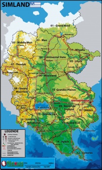
| Carte de Simland | |
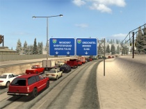
Les autoroutes nationales ou encore appelées inter-étatiques, sont des axes destinés à la circulation automobile de très grande capacité entre les villes de Simland. La circulation s'y fait sur des chaussées en sens unique, à plusieurs voies (au minimum 2x2 voies), afin d'y permettre une circulation fluide et à vive allure. Outre les déplacements automobiles, un grand nombre de camions de fret utilisent le système autoroutier simlandais.
Tableau
| Logo | Nom | Itinéraire | Situation/Surnom | Extrémités | Longueur |
|---|---|---|---|---|---|
| |
A1 | Nord-Sud | Centrale | Ofenberg (GN) <-> Sun City (CM) | 3000km |
| |
A2 | Nord-Sud | Occidentale | Verkhovsk (TH) <-> Sun City (CM) | 2500km |
| |
A3 | Nord-Sud | Orientale | Ofenberg (GN) <-> Cap Ten (AP) | 3200km |
| |
A4 | Est-Ouest | Centrale | New Amsterdam (QN) <-> A2 (GL) | 1000km |
| |
A5 | Est-Ouest | Septentrionale | A3 (UL) <-> A2 (SM) | 750km |
| |
A6 | Est-Ouest | Rive Sud du Grand Lac | A1 (BS) <-> A2 (GL) | 600km |
| |
A7 | Nord-Sud | Haute vallée de l'Avalon | Suim (SM) <-> A5 (MX) | 1250km |
| |
A10 | Nord-Sud | Isthme des Comores | A1 (CM) <-> A2 (CM) | 75km |
| |
A20 | Est-Ouest | Côte Russe | A2 (SD) <-> Russie | 400km |
| |
A23 | Est-Ouest | Centrale | Assuria (SD) <-> New Amsterdam (QN) | 1100km |
| |
A26 | Est-Ouest | Piémont des Snowy | A6 (GL) <-> Russie | 250km |
| |
A33 | Nord-Sud | Côte Américaine | Etats-Unis <-> A3 (GP) | 100km |
| |
A34 | Nord-Sud | Long Island | A3 (QN)<-> New Amsterdam (QN) | 100km |
| |
A35 | Est-Ouest | Whyalaska | Etats-Unis <-> A3 (WY) | 125km |
Autoroutes en projets
A24 > Idée lancée début septembre par le Ministre des Transports.
