Mercentille - William J. Clinton International : Différence entre versions
Un article de WikiSimland 3.0.
M |
|||
| Ligne 1: | Ligne 1: | ||
| − | + | {| class="toccolours" style="float:right;margin: 0em 0em 0em 1em;" | |
| − | | | + | |+ '''[[Aéroports de Simland]]''' |
| − | | | + | |- |
| − | | | + | ! colspan="2" align="center" valign="middle" height="40" style="font-weight: bold; font-size: 1em; background:#0e89b5; color: #ffffff" | <font size="4">[[Image:Icone-avion.jpg]]MERCENTILLE <br> W.J. CLINTON INTERNATIONAL</font size> |
| − | | | + | |- |
| − | | | + | | colspan="2" align="center" | [[Image:WJCAirportLogo.png|290px]] |
| − | | | + | |- |
| − | | | + | ! colspan="2" align="center" valign="middle" height="20" ; font-size: 1em; background: #ffffff; color: #000000"| Code [[AITA]] <br> '''WJC''' |
| − | | | + | |- |
| − | + | ! colspan="2" align="center" valign="middle" height="20" style="font-weight: bold; font-size: 1em; background:#0e89b5; color: #ffffff" | <font size="2">'''Localisation''' | |
| + | |- | ||
| + | | '''Pays'''|| align="center" | [[Simland]] [[Image:Drapeau de la Nation de Simland.jpg|22px]] | ||
| + | |- | ||
| + | | '''État''' || align="center" | [[Papaya]] [[Image:Papayadrapeau.jpg|22px]] | ||
| + | |- | ||
| + | | '''Ville''' || align="center" | [[Santa Maria]] [[Fichier:MercentilleFlag.png|22px]] | ||
| + | |- | ||
| + | | '''Superficie''' || align="center" | 2 900 ha | ||
| + | |- | ||
| + | | '''Altitude''' || align="center" | 15 m (51 ft) | ||
| + | |- | ||
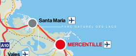
| + | | colspan="2" align="center" |[[Image:Localisationsm.png|280px]]<br> <small>Localisation de l'Aéroport International de Mercentille<br> (©[[La Cartographie Nationale|Cartographie Nationale]])</small> | ||
| + | |- | ||
| + | ! colspan="2" align="center" valign="middle" height="20" style="font-weight: bold; font-size: 1em; background:#0e89b5; color: #ffffff" | <font size="2">'''Pistes''' | ||
| + | |- | ||
| + | |- {| class="wikitable" align="center" style="font-size: 85%;" | ||
| + | |- | ||
| + | | bgcolor="#E4E4E4" | '''Direction''' || bgcolor="#E4E4E4" | '''Longueur''' | ||
| + | |- | ||
| + | | bgcolor="#efefef" | NC || NC | ||
| + | |- | ||
| + | ! colspan="2" align="center" valign="middle" height="20" style="font-weight: bold; font-size: 1em; background:#0e89b5; color: #ffffff" | <font size="2">'''Informations aéronautiques''' | ||
| + | |- | ||
| + | | '''[[Code AITA]]''' || align="center" | WJC | ||
| + | |- | ||
| + | | '''Code OACI''' || align="center" | MWJC | ||
| + | |- | ||
| + | | '''[[Code DACS]]''' || align="center" | PP.MT.M1 | ||
| + | |- | ||
| + | | '''Nom cartographique''' || align="center" | Mercentille <br> W. J. Clinton International | ||
| + | |- | ||
| + | | '''Type d'aéroport''' || align="center" | Civil | ||
| + | |- | ||
| + | | '''Gestionnaire''' || align="center" | Transport for Mercent | ||
| + | |- | ||
| + | ! colspan="2" align="center" valign="middle" height="20" style="font-weight: bold; font-size: 1em; background:#0e89b5; color: #ffffff" | <font size="2">'''Statistiques 2014''' | ||
| + | |- | ||
| + | | '''Passagers''' || align="center" | NC | ||
| + | |- | ||
| + | | '''Mouvements aériens''' || align="center" | NC | ||
| + | |- | ||
| + | | '''Cargo (tonnes métriques)''' || align="center" | NC | ||
| + | |- | ||
| + | | '''Impact économique''' || align="center" | NC | ||
| + | |- | ||
| + | |} | ||
-Topic en Cours de construction- | -Topic en Cours de construction- | ||
Version actuelle en date du 14 juin 2015 à 21:51
| W.J. CLINTON INTERNATIONAL | |
|---|---|

| |
| Code AITA WJC | |
| Localisation | |
| Pays | Simland |
| État | Papaya |
| Ville | Santa Maria |
| Superficie | 2 900 ha |
| Altitude | 15 m (51 ft) |
 Localisation de l'Aéroport International de Mercentille (©Cartographie Nationale) | |
| Pistes | |
| Direction | Longueur |
| NC | NC |
| Informations aéronautiques | |
| Code AITA | WJC |
| Code OACI | MWJC |
| Code DACS | PP.MT.M1 |
| Nom cartographique | Mercentille W. J. Clinton International |
| Type d'aéroport | Civil |
| Gestionnaire | Transport for Mercent |
| Statistiques 2014 | |
| Passagers | NC |
| Mouvements aériens | NC |
| Cargo (tonnes métriques) | NC |
| Impact économique | NC |
-Topic en Cours de construction-
| <span; style="font-weight: ; font-size: 1.0em; color: #ffffff ">Transports du Mercent</span> | | |
|---|---|---|
| Gare Mercentille - King George VI | ||
| Aéroports Mercentille - William J. Clinton International • Aéroport International de Santa Maria | ||
| Ports Portheaven Harbour • Port International de Santa Maria | ||

|
| |
Ceci est une page du Portail des transports | |
|---|---|---|
| Découvrez les infrastructures routières, aéroportuaires, ferroviaires et fluviales de Simland grâce au portail des transports. | ||