Oakdale County : Différence entre versions
Un article de WikiSimland 3.0.
(Page créée avec « {| class="toccolours" style="float:right;margin: 0em 0em 0em 1em;" |- ! colspan="2" align="center" valign="middle" height="40" style="font-weight: bold; font-size: 1em; ba... ») |
|||
| Ligne 5: | Ligne 5: | ||
| colspan="2" align="center" | | | colspan="2" align="center" | | ||
|- | |- | ||
| − | | <font color=# | + | | <font color=#A03434>'''Pays'''</font color> || align="center" | [[Simland]] [[Image:drapeausimland_ico.jpg]] |
|- | |- | ||
| − | | <font color=# | + | | <font color=#A03434>'''Région/Etat'''</font color> || align="center" | '''[[Génésie]] (GE)''' | 07 |
|- | |- | ||
| − | | <font color=# | + | | <font color=#A03434>'''District'''</font color> || align="center" | '''[[Carolie]]''' |
|- | |- | ||
! colspan="2" align="center" valign="middle" height="20" style="font-weight: bold; font-size: 1em; background: #A03434; color: #ffffff" | <font size="2">'''Administration''' | ! colspan="2" align="center" valign="middle" height="20" style="font-weight: bold; font-size: 1em; background: #A03434; color: #ffffff" | <font size="2">'''Administration''' | ||
|- | |- | ||
| − | | <font color=# | + | | <font color=#A03434>'''Chef-lieu'''</font color> || align="center" | [[Oakdale]] |
|- | |- | ||
! colspan="2" align="center" valign="middle" height="20" style="font-weight: bold; font-size: 1em; background: #A03434; color: #ffffff" | <font size="2">'''Données statistiques et géographiques''' | ! colspan="2" align="center" valign="middle" height="20" style="font-weight: bold; font-size: 1em; background: #A03434; color: #ffffff" | <font size="2">'''Données statistiques et géographiques''' | ||
|- | |- | ||
| − | |<font color=# | + | |<font color=#A03434>'''Population'''</font color> || align="center" | 543 602 hab. |
|- | |- | ||
| − | |<font color=# | + | |<font color=#A03434>'''Villes importantes'''</font color> || align="center" | [[Oakdale]] - Shadowsway - Montgomery |
|- | |- | ||
! colspan="2" align="center" valign="middle" height="20" style="font-weight: bold; font-size: 1em; background: #A03434; color: #ffffff" | <font size="2">'''Carte'''</font size> | ! colspan="2" align="center" valign="middle" height="20" style="font-weight: bold; font-size: 1em; background: #A03434; color: #ffffff" | <font size="2">'''Carte'''</font size> | ||
Version du 1 décembre 2012 à 14:41
| Oakdale County | |
|---|---|
| Pays | Simland |
| Région/Etat | Génésie (GE) | 07 |
| District | Carolie |
| Administration | |
| Chef-lieu | Oakdale |
| Données statistiques et géographiques | |
| Population | 543 602 hab. |
| Villes importantes | Oakdale - Shadowsway - Montgomery |
| Carte | |

| |
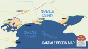
Oakdale County un comté de Génésie, situé au nord-ouest de l'État. Sa population est de 543 602 habitants. Son chef-lieu est Oakdale.
Principalement connu grâce à son chef-lieu de plus de 500 000 habitants, Oakdale, le district, du fait de sa taille (1/5 de celle de la Carolie), est très peu dense, mais a un grand pôle de population très dense à son extrême nord-est, avec Oakdale. Le district est également marqué par le Lac Midson/Montgomery Lake, et ses magnifiques paysages.